Search

Search Results

Ile de Baly ou petite Java

event1770

location_onIndonesia

Amongst the mountains and jungles of mid-18th century Bali, this map shows three royal palaces, walled encampments, towns, and seven Buddhist temples (or ‘stupa’) on the east coast. Inset illustrations depict a palace and a temple in detail.

Das eyland Baly oder klein Java

event1750

location_onIndonesia

Amongst the mountains and jungles of mid-18th century Bali, this map shows three royal palaces, walled encampments, towns, and seven Buddhist temples (or ‘stupa’) on the east coast. Inset illustrations depict a palace and a temple in detail.

Baly

event1616

location_onIndonesia

This early 17th century map of the island of Bali shows palaces, settlements and possibly some temples. Ships can be seen at anchor around the coast. The map is from a Latin language book which includes text describing Bali.

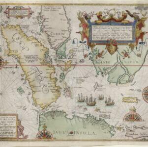
Nova tabula insularum Iavae, Sumatrae, Borneonis et aliarum Mallaccam usquae

event1598

location_onMalaysia, Indonesia, Singapore

Adapted by Theodore de Bry from an original by Willem Lodewycksz, this map has some inaccuracies e.g. the Malay Peninsula (‘Chersonese’) is completely bisected by the Muar River, leaving the southern tip of the peninsula as a separate island.

close

  • Filter from 1598 to 1770

Current results range from 1598 to 1770