Search

Search Results

Plan de l'Archipel de Merguy / Plan de l'Isle Junkseilon

event1775

location_onMyanmar, Thailand

Two coastal navigation maps: one of the Mergui Archipelago off the west coast of Myanmar; and one of Phuket (‘Isle Junkseilon’) and the surrounding islands off the west coast of Thailand. Both feature bathymetry (sea depth), shoals and reefs.
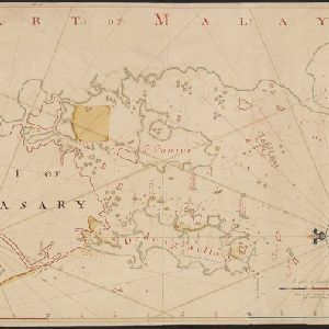
Part of Malaya. Part of Tanasary

event1738

location_onMalaysia, Thailand

This map was intended for navigation purposes, with bathymetry (sea depth), reefs, shoals and anchor points marked. One island is labelled ‘like a sugar loaf’, another ‘like a turtel [turtle]’. Oedong Sallang is the island of Phuket, Thailand.

close

  • Filter from 1738 to 1775

Current results range from 1738 to 1775