Search

Search Results

Western part of the Java Sea : from Lucipara I. to Sunda Strait and Batavia

event1866

location_onIndonesia

Designed to aid navigation around the western Java Sea, this map features bathymetry (sea depth), current and tide data, and is marked with shoals, reefs and other hazards. Written notes add details at specific locations (e.g. ‘heavy tide rips’).

Nederlandsch Oost-Indië

event1865

location_onBrunei, Cambodia, East Timor, Indonesia, Laos, Malaysia, Myanmar, Vietnam, Thailand, Southeast Asia, Singapore, Philippines, Papua New Guinea

This detailed map of the Dutch East Indies in the mid-19th century contains a great deal of information: topographical details, settlements and administrative areas, roads, railways and maritime routes, telegraph lines, inset maps etc.

Chart of the China Sea

event1864

location_onPapua New Guinea, Indonesia, Malaysia, Cambodia, East Timor, Philippines, Singapore, Thailand, Vietnam

To aid navigation, this map shows small islands, shoals and reefs, maritime routes for use during monsoons or at particular times of the year, bathymetry (sea depth), tide information, shipwrecks, compass roses and landmark mountains at the coasts.

China Sea: Strait of Macassar to Celebes Sea

event1864

location_onIndonesia

Navigation map of the Celebes Sea, Makassar Strait and Java Sea, with bathymetry (sea depth), maritime routes, shoals and reefs, and landmark coastal mountains to aid navigation. On two sheets, which may not be from the same original map.

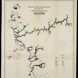
Bijdrage tot eene geologische kaart der residentie Westerafdeeling van Borneo

event1858

location_onIndonesia

A geological map of western Borneo made by a mine engineer, showing the types of soil, coal, clay, and rock (limestone, sandstone, granite, basalt), as well as gold, diamonds, tin, copper and iron found along the rivers.

Arracan: chart of the entrance to the river

event1858

location_onMyanmar

This navigation map of the mouth of the Kaladan River on the west coast of Arracan (modern Myanmar) features drawings of coastal features (elevations), bathymetry (sea depth), shoals and reefs, landmarks, and notes on how to enter the river safely.

Reede van Bengkoelen

event1856

location_onIndonesia

Map of the bay at Bengkoelen (Bengkulu, west coast of Sumatra), with bathymetry (sea depth), islands, shoals and reefs marked. Two lighthouses are shown, with lines to indicate the limits of their range.

Reede van Bengkoelen

event1856

location_onIndonesia

Map of the bay at Bengkoelen (Bengkulu, west coast of Sumatra), with bathymetry (sea depth), islands, shoals and reefs marked. Two lighthouses are shown, with lines to indicate the limits of their range.

Map of Prince of Wales' Island or Pulo Penang and province Wellesley

event1853

location_onMalaysia

Map of the Penang Strait, including written instructions on how to navigate the strait. On land, areas of cultivation are marked, with a table listing acreage used for each crop. A boundary with Siam based on an 1831 treaty is also shown.

Carte de l'ile de Java

eventc.1850

location_onIndonesia

Map of Java and Madura divided into administrative districts, and featuring mountains, settlements and major roads. There is an inset map of the port city of Batavia (Jakarta) and its surrounding fields and countryside.

Carte de l'ile de Java

eventc.1850

location_onIndonesia

Map of Java and Madura divided into administrative districts, and featuring mountains, settlements and major roads. There is an inset map of the port city of Batavia (Jakarta) and its surrounding fields and countryside.

Algemeene Kaart van Nederlandsch Oostindie

event1842

location_onEast Timor, Indonesia, Malaysia, Singapore

This detailed map of the Dutch East Indies in the mid-19th century is spread over eight sheets, plus a cover sheet showing the whole area. There are numerous inset maps of islands, bays, cities etc.

close