Search

Search Results

Karte von Hoch-Asien: zu C. Ritter's Erdkunde, Buch II, Asien

event1833

location_onMyanmar

Four-sheet map of Asia from Carl Ritter’s book ‘Erdkunde [Geography]’, including the northwest Birman Empire (Myanmar) and featuring rivers, mountains, administrative districts and settlements. Plus a page of elevations of Asian mountain ranges.

Ostindien: 1833

event1833

location_onCambodia, Indonesia, Laos, Malaysia, Myanmar, Thailand, Vietnam, Singapore

Map of India and mainland Southeast Asia, with coloured borders indicating European colonial possessions.

Karte von Hoch-Asien: zu C. Ritter's Erdkunde, Buch II, Asien

event1833

location_onMyanmar

Four-sheet map of Asia from Carl Ritter’s book ‘Erdkunde [Geography]’, including the northwest Birman Empire (Myanmar) and featuring rivers, mountains, administrative districts and settlements. Plus a page of elevations of Asian mountain ranges.

Ostindien: 1833

event1833

location_onCambodia, Indonesia, Laos, Malaysia, Myanmar, Thailand, Vietnam, Singapore

Map of India and mainland Southeast Asia, with coloured borders indicating European colonial possessions.

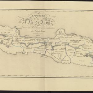
Esquisse de l'ile de Java: divisée en Residences avec indication des chefs-lieux

event1833

location_onIndonesia

Map of Java divided into Dutch administrative areas (‘residencies’), and the Empire of Soerakarta and Kingdom of Djokjakarta, which were under indigenous rule (a note records the territories these indigenous areas lost in the Java War (1825–1830)).

close