Search

Search Results

A new and accurate map of the Empire of the Great Mogul, together with India on both sides of the Ganges, and the adjacent countries

eventc.1740

location_onCambodia, Indonesia, Laos, Malaysia, Myanmar, Singapore, Thailand, Vietnam

Notes on this map describe European colonial territories and trade with Asia, though this is concentrated around India, and mostly has not yet reached further east to ‘India extra Gangem [India beyond the Ganges]’ as Southeast Asia is labelled.

L'Asie, selon les nouvelles observations de Messrs. de l'Academie des Sciences

event1713

location_onBrunei, Cambodia, East Timor, Indonesia, Laos, Malaysia, Myanmar, Philippines, Singapore, Southeast Asia, Thailand, Vietnam

This early 18th century map of Asia features a drawing of a woman burning offerings on an altar, while two children carry cornucopias, and a camel looks on. The Roman god Mercury descends from the sky in the background wearing his winged helmet.

Asiae Nova Descriptio

event1679

location_onBrunei, Cambodia, East Timor, Indonesia, Laos, Malaysia, Myanmar, Philippines, Singapore, Southeast Asia, Thailand, Vietnam

The seas on this early map of Asia are decorated with sailing ships and sea monsters. The cartouche features an illustration of two Asian men carrying bows and arrows.

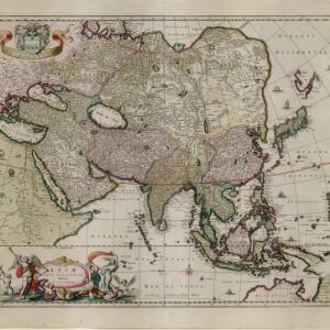
Asiæ nova delineatio

eventc.1656-1677

location_onBrunei, Cambodia, East Timor, Indonesia, Laos, Malaysia, Myanmar, Philippines, Singapore, Southeast Asia, Thailand, Vietnam

This colourful mid-17th century map was originally published in the Dutch cartographer Nicolaes Visscher's ‘Atlas contractus’. The map is dedicated to D. Henry Spiegel, consul and senator of the city of Amsterdam, and features his coat of arms.

India Orientalis

event1634

location_onBrunei, Cambodia, Indonesia, Laos, Malaysia, Myanmar, Philippines, Thailand, Vietnam, Singapore, Southeast Asia

This 17th century map features a number of mythical lakes once thought to exist in southern China. One of these lakes (‘Chiamai Lac’) feeds three rivers—labelled ‘Menan’, ‘Manthabam’ and ‘Cosmin’—which flow south through mainland Southeast Asia.

India orientalis

event1630

location_onBrunei, Cambodia, Indonesia, Laos, Malaysia, Myanmar, Philippines, Singapore, Southeast Asia, Thailand, Vietnam

Four long rivers flow south through mainland Southeast Asia on this map: the ‘Menan’, ‘Manthabam’ and ‘Cosmin’ originate at a mythical lake (‘Chiamai Lacus’) in southern China, while the ‘Mecon’ (Mekong) flows from the hills of Cochinchina (Vietnam).

Descriptio Indiæ orientalis

event1607

location_onBrunei, Cambodia, Indonesia, Laos, Malaysia, Myanmar, Philippines, Singapore, Southeast Asia, Thailand, Vietnam

This early 17th century map features a number of mythical lakes that were once thought to exist in southern China. One of these lakes feeds three rivers—labelled ‘Menam’, ‘Manthabam’ and ‘Cosmin’—which flow south through mainland Southeast Asia.

India orientalis

eventc.1600-1699

location_onVietnam, Myanmar, Malaysia, Philippines, Singapore, Southeast Asia, Thailand, Laos, Indonesia, Cambodia, Brunei

This 17th century map features a number of mythical lakes once thought to exist in southern China. One of these lakes (‘Chiamai Lac’) feeds three rivers—labelled ‘Menan’, ‘Manthabam’ and ‘Cosmin’—which flow south through mainland Southeast Asia.

Tabvla Asiæ VIII

eventc.1596-1621

location_onMyanmar

Early map by Giovanni Antonio Magini, based on the work of the 2nd century geographer Ptolemy. It is difficult to pinpoint exact locations, but the area labelled ‘India Extra Ganges [India beyond the Ganges]’ could include some of modern Myanmar.

close