Search

Search Results

Kaart van het Midden-en Zuidelyk Gedeelte van den Molukschen Archipel

event1854

location_onIndonesia, East Timor

Map of some of the Maluku islands around the Banda Sea, colour-coded by their administrative region, and with an elevation showing heights of mountains. (From ‘Algemeene Atlas van Nederlandsche Indie [General Atlas of the Dutch East Indies]’.)

Kaart van Amboina en eenige aangrenzende eilanden

event1854

location_onIndonesia

Map of Amboina (Ambon) and surrounding islands just south of Ceram (Seram). An elevation (side view) of the islands shows the heights of their mountains. (From ‘Algemeene Atlas van Nederlandsche Indie [General Atlas of the Dutch East Indies]’.)

De landvoogdy van Amboina met de elf onderhoorige eylanden

event1726

location_onIndonesia

Although mainly a navigation map—with a rhumbline network and elevations of mountains—there are also many terrestrial details shown, such as settlements and mountains. The inset map of Hoeamohel details plantations and the cultivation of nut crops.

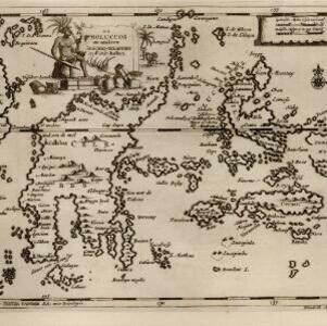
De Moluccos en andere Speceri-Eilanden in d'Oost-Indien

event1714

location_onIndonesia

Map of the ‘Spice Islands’ of maritime Southeast Asia, including the Maluku Islands. It is decorated with a drawing of an Asian man holding a large bird and a spear, and surrounded by baskets and boxes of goods of the spice trade.

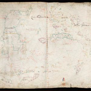
[Dutch portolan chart of the eastern Dutch East Indies]

event1700

location_onIndonesia, East Timor

This colourful hand-drawn portolan (nautical) chart was designed to aid navigation. It features a rhumbline network (the web of interconnected lines), bathymetry (sea depth), shoals and reefs, anchor points and written notes.

close

  • Filter from 1700 to 1854

Current results range from 1700 to 1854