Search

Search Results

Kaart van het Midden-en Zuidelyk Gedeelte van den Molukschen Archipel

event1854

location_onIndonesia, East Timor

Map of some of the Maluku islands around the Banda Sea, colour-coded by their administrative region, and with an elevation showing heights of mountains. (From ‘Algemeene Atlas van Nederlandsche Indie [General Atlas of the Dutch East Indies]’.)

Kaart van Amboina en eenige aangrenzende eilanden

event1854

location_onIndonesia

Map of Amboina (Ambon) and surrounding islands just south of Ceram (Seram). An elevation (side view) of the islands shows the heights of their mountains. (From ‘Algemeene Atlas van Nederlandsche Indie [General Atlas of the Dutch East Indies]’.)

Zoological Geography: Sheet No. 5

event1849

location_onBrunei, Cambodia, East Timor, Indonesia, Laos, Malaysia, Myanmar, Papua New Guinea, Philippines, Singapore, Southeast Asia, Thailand, Vietnam

Four world maps showing the distribution of reptiles and snakes, including in Southeast Asia. Lines show the geographical range of individual species, alongside illustrations of some of the animals featured.

Algemeene Kaart van Nederlandsch Oostindie

event1842

location_onEast Timor, Indonesia, Malaysia, Singapore

This detailed map of the Dutch East Indies in the mid-19th century is spread over eight sheets, plus a cover sheet showing the whole area. There are numerous inset maps of islands, bays, cities etc.

Algemeene kaart van Nederlandsch Oostindie

eventc.1839-1855

location_onEast Timor, Indonesia, Malaysia, Singapore

This map of the Dutch East Indies is spread over eight sheets, with a hand-drawn cover sheet showing the whole area. There are numerous inset maps of islands, bays, cities etc. Two of the inset maps have a replacement map pasted over them.

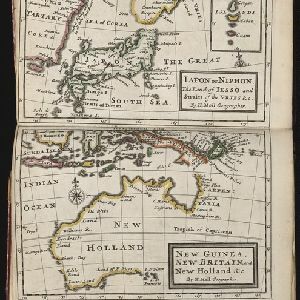
Iapon or Niphon the land of Iesso and Straits of the Vries / New Guinea, New Britain, and New Holland &c.

event1732

location_onEast Timor, Indonesia, Papua New Guinea

The London-based cartographer Herman Moll (1654?–1732) created this map of New Guinea and the neighbouring islands of maritime Southeast Asia. It shows that in the 1730s, the details of New Guinea and Australia (‘New Holland’) were uncertain.

De landvoogdy van Amboina met de elf onderhoorige eylanden

event1726

location_onIndonesia

Although mainly a navigation map—with a rhumbline network and elevations of mountains—there are also many terrestrial details shown, such as settlements and mountains. The inset map of Hoeamohel details plantations and the cultivation of nut crops.

Description de la coste septentrionale de Noua Guinea

event1618

location_onIndonesia

The north coast of New Guinea is mapped here as it was discovered by the Dutch explorer Willem Corneliszoon Schouten. He is named on the map as Guillaume Schouten de Hoorn, known as the first to sail from Europe to the Pacific Ocean via Cape Horn.

Description de la grande mer du Sud monstrant par quel chemin Guillaume Schouten a navige

event1618

location_onIndonesia, Papua New Guinea

This map shows the route of the Dutch explorer Willem Corneliszoon Schouten, crossing the Pacific Ocean from South America to New Guinea. He was the first explorer to sail from Europe to the Pacific Ocean via Cape Horn.

Description de la coste septentrionale de Noua Guinea

event1618

location_onIndonesia

The north coast of New Guinea is mapped here as it was discovered by the Dutch explorer Willem Corneliszoon Schouten. He is named on the map as Guillaume Schouten de Hoorn, known as the first to sail from Europe to the Pacific Ocean via Cape Horn.

close