Search

Search Results

Prèsqu'ile de Malacca

event1827

location_onMalaysia, Indonesia, Singapore

By Belgian geographer Philippe Vandermaelen (1795–1869), this 19th century map of the Malay Peninsula also features the Riau Islands—including the Anambas and Natuna islands in the South China Sea—the Straits of Malacca and the Singapore Strait.

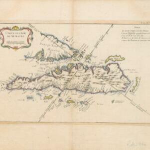
Carte de l'Isle de Sumatra

event1764

location_onMalaysia, Indonesia, Singapore

This mid-18th century map shows the island of Sumatra and the Malay Peninsula, divided by the Straits of Malacca. A note in French at the top right corner states that the interior of Sumatra and the course of its rivers are unknown.

Carte réduite des détroits de Malaca, Sincapour, et du Gouverneur

event1755

location_onMalaysia, Singapore, Indonesia

Maps like this aided navigation through the islands, shoals and reefs of Singapore and the Malacca Strait. Three routes around Singapore are shown, numbers on the sea indicate water depth, and the profile views of mountains were used as landmarks.

close

  • Filter from 1755 to 1827

Current results range from 1755 to 1827