
Search Results

Asie pour La Géographie Comparée: Seconde partie
1778
Brunei, Cambodia, East Timor, Indonesia, Laos, Malaysia, Myanmar, Papua New Guinea, Philippines, Singapore, Southeast Asia, Thailand, Vietnam
On this map of Asia, New Guinea is shown as two separate islands—the western part as ‘Isle de Papous’ and the eastern part as ‘Nouvelle Guinée’—showing that in the 1770s the details of the region were uncertain.
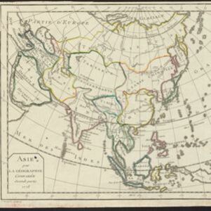

Carte Plate du Golfe de Siam: avec une partie des Côtes de Malaye et de Camboje, depuis l'Isle Timon, jusqu'à celle Condor
1775
Cambodia, Malaysia, Thailand
Map of the Gulf of Siam (Gulf of Thailand) with shoals and small islands marked. The web of lines is a rhumbline network, while the numbers indicate sea depth (bathymetry), both used to aid navigation. There is an inset map of the Redang Archipelago.


