Search

Search Results

Topographische kaart der residentie Pekalongan

event1870

location_onIndonesia

Topographic map of the residency of Pekalongan (Central Java), divided into regencies (pink borders) and districts (yellow borders). Mountains, forests, settlements, routes, crops—alang-alang, coffee, sugar, rice—factories and warehouses are shown.

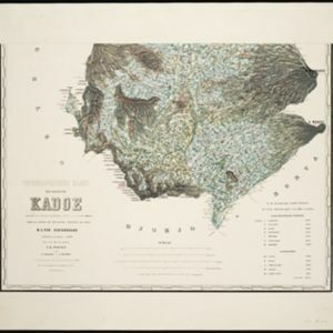
Topographische kaart der residentie Kadoe

event1870

location_onIndonesia

The residency of Kadoe (Kadu), Central Java, is shown divided into regencies and districts, with population figures for each district. Villages (kampongs) and towns, fields, mountains, rivers and roads are marked. There is an inset triangulation map.

Topographische kaart der residentie Japara

event1870

location_onIndonesia

Four-sheet topographic map of the residency of Japara (Jepara, Central Java), with an inset signal map of locations’ heights and distances. Administrative districts, crops—coffee, alang-alang, rice, sugarcane, coconut—and fishing ponds are shown.

Topographische kaart der residentie Djokjakarta

event1870

location_onIndonesia

The residency of Djokjakarta (Yogyakarta), southern Java, featuring crops (coffee, sugar, rice, alang-alang, tobacco, indigo plants, nipa palm, bamboo); warehouses, cemeteries, post offices; routes, administrative borders; mountains, rivers.

Topographische kaart der residentie Tagal

event1870

location_onIndonesia

The lower half of this two-sheet topographic map of the residency of Tagal (Tegal, Central Java) is dominated by mountains, with the upper half split between forests and rice paddies, and the larger settlements near the coast.

Ostindische Inseln

eventc.1870

location_onBrunei, Cambodia, East Timor, Indonesia, Laos, Malaysia, Myanmar, Philippines, Singapore, Southeast Asia, Thailand, Vietnam

On this map of Southeast Asia, borders are outlined and cities underlined in different colours to show the colonial territories of the European powers. On Borneo, the names of indigenous peoples are listed (‘Dayak’s, Papua’s, Bugi’s’).

Kaart van de Minahassa in de residentie Manado

event1869

location_onIndonesia

On this map of the northern tip of the Minahasa Peninsula, the roads have been added in pencil after the map was printed. Similarly, the elevation (side view) of the peninsula’s mountains has the route of a journey added in pencil.

Sumatra

event1868

location_onIndonesia

The use of hachures—short lines/dashes that give a sense of the shape and steepness of terrain—highlight the mountain ranges along the west coast of Sumatra, with rivers flowing east. The island is divided into administrative ‘residencies’.

Topographische kaart der residentie Soerakarta

event1867

location_onIndonesia

The residency of Soerakarta (Surakarta), Central Java, featuring crops (coffee, sugarcane, rice, sugar); warehouses (coffee, sugar, tobacco, indigo plant); factories (sugar, tobacco, indigo plant); routes (railway, postal, road).

Plattegrond der stad Soerabaija

event1867

location_onIndonesia

A mid-19th century map of the city of Soerabaija (Surabaya, East Java, Indonesia) showing its recently built defences, including the ‘Citadel Prins Hendrik’ fort and a walled moat. Outside the city are villages, plantations and fields.

Kaart van de residentie Kadoe

event1867

location_onIndonesia

The residency of Kadoe in Central Java is shown divided into two regencies (yellow border) and 12 districts (blue borders). At the left edge, there are drawings (called elevations) of the side views of the area’s mountains, marked with their heights.

close

  • Filter from 1570 to 1900

Current results range from 1570 to 1900