Search

Search Results

Mer des Indes: cartes de la direction et de l'intensité probables des vents

event1880

location_onBrunei, Cambodia, Indonesia, Malaysia, Myanmar, Philippines, Thailand, Vietnam, Singapore

A series of four maps of the Indian Ocean—one for each quarter of the calendar year—showing the direction and intensity of the winds, including around the seas of Southeast Asia. There are extensive explanatory notes.

Kaart van het eiland Sumatra

event1880

location_onMalaysia, Indonesia, Singapore

The use of hachures—short lines/dashes that give a sense of the shape and steepness of terrain—highlight the mountain ranges along the west coast of this map of Sumatra. Many rivers flow east from the mountains to the Malacca Strait.

Topographische en geologische kaart van Zuid-Sumatra bevattende de residentien Bengkoelen, Palembang en Lampongsche Districten

event1880

location_onIndonesia

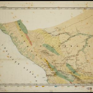
A topographical and geological map of southern Sumatra, over four sheets. Areas of igneous and sedimentary rock, coal, fossils, petroleum, active volcanoes and hot springs are marked, along with mountains, rivers and marshland, roads and settlements.

Gulf of Siam: Malay Peninsula - East Coast. Lakon Roads to Lem Tane

event1880

location_onThailand

Produced by the British Admiralty’s Hydrographic Office, this map includes various navigational aids, such as maritime routes, bathymetry (sea depth), tide and current data, and elevations (side views of hills and mountains to use as landmarks).

close