Search

Search Results

India

event1895

location_onMyanmar

On this map of India, Burma (Myanmar) is divided into administrative regions. Borders with India and Siam are hand-coloured.

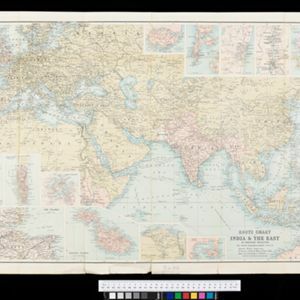
Route chart to India and the East

event1895

location_onBrunei, Cambodia, East Timor, Indonesia, Laos, Malaysia, Myanmar, Philippines, Singapore, Southeast Asia, Thailand, Vietnam

Map of Asia featuring steamship routes—including around Southeast Asia—connecting ports such as Penang, Singapore, Batavia (Jakarta), Saigon, Bangkok, Rangun (Yangon), Manila, Macassar (Makassar) etc. There is also an inset map of Singapore.

Riouw-archipel: Reede Riouw

event1895

location_onIndonesia

Navigation map of the Riau Roadstead (off west coast of Bintan, Riau Archipelago): a body of water sheltered from tides/currents, for ships to anchor. Bathymetry (sea depth) and various obstructions and landmarks (hills, buildings, trees) are shown.

Kaart van het gebied bezet in Groot-Atjeh

event1895

location_onIndonesia

A large-scale map of Aceh, north Sumatra, spread over four sheets with details such as routes (rivers, roads, railways), crops (rice, banana, pepper, sugarcane, bamboo), land features (mountains, forests, wetlands) and settlements (cities, villages).

Sumatra: Residentie Benkoelen (Bengkoelen)

eventc.1894-1895

location_onIndonesia

Map of the residency of Benkoelen (Bengkulu, southwest coast of Sumatra), over 10 sheets, with an inset map of the city of Bengkoelen (Bengkulu). Types of crops—coconut, rice, alang-alang, nipah palm, coffee—are marked. Sheet number 8 is missing.

Java: Residentie Besoeki

event1895

location_onIndonesia

There are over 100 sheets of this very large-scale (1:20,000) topographic map of the regency of Besoeki, Java. Cities and villages, roads, railways and rivers, crops and many more features are all shown in great detail.

Kaart aantoonende districtsgewijs den aard van het grondbezit op Java en Madoera

event1895

location_onIndonesia

This map shows Java and Madura divided into regencies which are then subdivided into districts. Each district is coloured to represent land ownership (‘Communaal bezit [Communal property]’) as recorded in 1895.

Lombok

event1895

location_onIndonesia

Two maps of Lombok (Lesser Sunda Islands) from the time of the Dutch intervention which led to the colonisation of the island. Both maps focus on roads: the first covers the whole island; the second focuses on the capital city of Mataram.

Kei- of Ewaf-eilanden

event1895

location_onIndonesia

Map of the Kai Islands, in the Banda Sea, designed for navigation: it features bathymetry (sea depth), tide data (arrows), reefs and shoals. Obstructions in the water are marked ‘kr’ (coral), ‘m’ (mud), ‘s’ (shells), ‘st’ (stones), and ‘z’ (sand).

Residentie Soerabaja

event1895

location_onIndonesia

There are 64 sheets of this very large-scale (1:20,000) topographic map of the regency of Soerabaja (East Java). Cities and villages, roads, railways and rivers, crops and many more features are all shown in great detail. First sheet is an overview.

Stromkarte von West Borneo... mit Angabe der Stationen und Routen der Niederländischen Expedition in den Jahren 1893 und 1894

event1895

location_onIndonesia

The route of a late 19th century expedition by Dutch geologists, botanists, ethnographers and zoologists is marked on this map of southwest Borneo. Mountain peaks which were surveyed by the geologists are highlighted with a red circle.

Upper Burma

event1895

location_onMyanmar, Thailand

Map of Upper Burma, showing the borders with Assam (India), China and Siam (Thailand), as well as internal administrative borders. Mountains with their heights, settlements, rivers and railways (completed, proposed and under construction) are shown.

close