Search

Search Results

Deese wassende pas-kaart van Oost-Indien, is nu te bekoomen voor die deselve begeeren

eventc.1728-1738

location_onBrunei, Cambodia, East Timor, Indonesia, Laos, Malaysia, Myanmar, Papua New Guinea, Philippines, Singapore, Southeast Asia, Thailand, Vietnam

Map of the Indian Ocean dominated by a rhumbline network—a web of interconnected lines used to help plot routes—with a compass rose at the centre. At the top there are (incomplete) drawings of people with text in Dutch, French, English and Spanish.

Insulae Iavae pars Occidentalis

event1728

location_onIndonesia

A map of Java with mountains, jungles, animals and crops. Bathymetry (sea depth) is marked, including on an inset map of Batavia harbour. Illustrations include Batavia Castle, and a lion—representing Belgium—receiving tribute and enslaving locals.

Insulae Iavae pars Occidentalis

eventc.1720

location_onIndonesia

A map of west Java with mountains, jungles, animals and crops. Details include sea depth, an inset map of Batavia harbour, and an illustration of a lion—representing Belgium—receiving tribute and enslaving locals. A similar map of east Java was made.

Insulae Iavae Pars Orientalis

eventc.1720

location_onIndonesia

A map of eastern Java with mountains, jungles, animals and crops. Bathymetry (sea depth) is marked, and there is a painting of Batavia harbour and castle. A similar map depicting western Java was also produced, as were maps featuring both parts.

Insulae Iavae Pars Occidentalis / Insulae Iavae Pars Orientalis

eventc.1720

location_onIndonesia

A map of Java with mountains, jungles, animals and crops. Bathymetry (sea depth) is marked, including on an inset map of Batavia harbour. Illustrations include Batavia Castle, and a lion—representing Belgium—receiving tribute and enslaving locals.

Insulae Iavae pars Occidentalis

eventc.1710-1719

location_onIndonesia

A map of Java with mountains, jungles, animals and crops. Bathymetry (sea depth) is marked, including on an inset map of Batavia harbour. Illustrations include Batavia Castle, and a lion—representing Belgium—receiving tribute and enslaving locals.

Indiae orientalis, nec non insularum adiacentium

event1698

location_onMyanmar, Philippines, Singapore, Southeast Asia, Thailand, Vietnam, Malaysia, Laos, Indonesia, East Timor, Cambodia, Brunei

The cartouche on this map of Asia is decorated with a colourful painting illustrating the region’s commerce, with Asian merchants displaying an assortment of goods, including jewellery, porcelain vessels and figurines, textiles and exotic animals.

[Chart of the Indian Ocean]

event1682

location_onCambodia, Indonesia, Malaysia, Myanmar, Singapore, Thailand

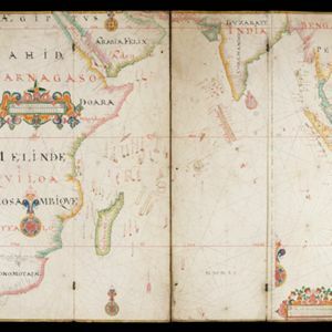
Colourful hand-drawn portolan (nautical) navigation chart, featuring a rhumbline network (the web of interconnected lines), islands, shoals and reefs. With elaborately decorated scales and compass roses. Mounted on folding wood boards.

Mar di India

event1659

location_onBrunei, Cambodia, East Timor, Indonesia, Laos, Malaysia, Myanmar, Philippines, Singapore, Southeast Asia, Thailand, Vietnam

This mid-17th century map of the Indian Ocean has a colourful cartouche illustrated with paintings of Asian merchants and warriors with bows and arrows. The scale is decorated with paintings of cherubs.

Mar di India

event1644

location_onBrunei, Cambodia, East Timor, Indonesia, Laos, Malaysia, Myanmar, Philippines, Singapore, Southeast Asia, Thailand, Vietnam

This mid-17th century map of Southeast Asia is from Isaac Commelin’s book describing the voyages of the Dutch East India Company ‘Begin ende voortgangh…’. There is an inset map of the island of Botton (Buton Island, southeast of Celebes (Sulawesi)).

close