Search

Search Results

Carte des Indes Orientales: 2de. feuille

event1748

location_onBrunei, East Timor, Indonesia, Malaysia, Philippines, Vietnam

This map features a label noting that the Byayos people inhabited the mountains of central Borneo. Another note at the northeast tip of Borneo states that the location and number of islands in the area is uncertain. Sheet two of two.

Carte des Indes Orientales: I. feuille

event1748

location_onMyanmar, Cambodia, Indonesia, Laos, Malaysia, Singapore, Thailand, Vietnam

Map featuring the ancient kingdoms of mainland Southeast Asia. The cartouche is embellished with maritime and military paraphernalia. The map is dedicated to William IV, Prince of Orange (Guillaume Charles Henry Friso). Sheet one of two.

Carte des Indes Orientales: 2de. feuille

event1748

location_onBrunei, East Timor, Indonesia, Malaysia, Philippines, Vietnam

This map features a label noting that the Byayos people inhabited the mountains of central Borneo. Another note at the northeast tip of Borneo states that the location and number of islands in the area is uncertain. Sheet two of two.

Carte des Indes Orientales: I. feuille

event1748

location_onMyanmar, Cambodia, Indonesia, Laos, Malaysia, Singapore, Thailand, Vietnam

Map featuring the ancient kingdoms of mainland Southeast Asia. The cartouche is embellished with maritime and military paraphernalia. The map is dedicated to William IV, Prince of Orange (Guillaume Charles Henry Friso). Sheet one of two.

Carte des Indes Orientales: 2de. feuille

event1748

location_onBrunei, East Timor, Indonesia, Malaysia, Philippines, Vietnam

This map features a label noting that the Byayos people inhabited the mountains of central Borneo. Another note at the northeast tip of Borneo states that the location and number of islands in the area is uncertain. Sheet two of two.

Carte des Indes Orientales

event1748

location_onBrunei, Cambodia, East Timor, Indonesia, Laos, Malaysia, Myanmar, Philippines, Singapore, Southeast Asia, Thailand, Vietnam

This mid-18th century map features a label noting that the Byayos people inhabited the mountains of central Borneo. Another note at the northeast tip of Borneo states that the location and number of islands in the area is uncertain.

Chart of the China Sea

event1746

location_onBrunei, Cambodia, Indonesia, Malaysia, Philippines, Vietnam

This map features eight expedition routes across the South China Sea from 1752 to 1763. The web of lines is a rhumbline network, and bathymetry (sea depth) is marked. The place names are in French, but with an English title and notes.

India orientalis

event1744

location_onBrunei, Cambodia, East Timor, Indonesia, Laos, Malaysia, Myanmar, Philippines, Singapore, Southeast Asia, Thailand, Vietnam

This map features a rhumbline network, a web of lines to help plot routes and aid navigation. Where the lines meet, there is a compass rose with an arrow pointing to north.

Particular-see-charte der Strass Sunda, nebst denen darinnen befindlichen insulen und sandbäncken

event1744

location_onIndonesia

A navigation map of part of the north coast of Java, featuring the ports of Batavia (Jakarta) and Bantam (Serang). Includes colourful paintings of a ‘menschen fressers [cannibal]’ island, Javanese people and palm trees (dates, banana, coconut).

Nieuwe afteekeningh van de Noord Küst van Java vertoonende de reede van Batavia en Bantem

event1740

location_onIndonesia

A map of the northern coast of Java and the important port cities of Batavia (Jakarta) and Bantem (Banten). The web of lines is a rhumbline network, and shoals, reefs and bathymetry (sea depth) are marked, all to aid navigation.

Chart of the North Coast of Java from Samarang to Batavia

event1740

location_onIndonesia

This map uses a variety of methods to aid navigation, including a rhumbline network (a web of lines to help plot routes). The numbers on the sea surface indicate depth (bathymetry), and the drawings of mountains (elevations) were used as landmarks.

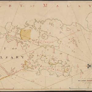
Part of Malaya. Part of Tanasary

event1738

location_onMalaysia, Thailand

This map was intended for navigation purposes, with bathymetry (sea depth), reefs, shoals and anchor points marked. One island is labelled ‘like a sugar loaf’, another ‘like a turtel [turtle]’. Oedong Sallang is the island of Phuket, Thailand.

close