Search

Search Results

Kaart van 't noordwestelijke gedeelte der Residentie Ambon

event1898

location_onIndonesia

Map of the residency of Ambon in the Maluku Islands, divided by colour-coded administrative borders. There are inset maps the Banda Islands—including the nutmeg plantations and the town of Neira with its fort and hospital—and of Dutch New Guinea.

Kaart der Molukken

event1898

location_onIndonesia, East Timor

Map of the Moluccas (Maluku Islands) divided into the residencies of Ternate (orange borders) and Ambon (green borders). Many place names are in Dutch and Malay, and there is an inset map of the city of Ambon. Timor is marked as Portuguese territory.

Schetskaart van West-Seran (Vulgo Ceram) / Schetskaart van Oost- en Midden Seran

event1896

location_onIndonesia

Map of the island of Seram in the Maluku Islands, originally produced as two separate maps. Red lines show lines of communication of local people (referred to as ‘Alfoer’), with their tribe’s name. Muslim, Christian and Alfoer settlements are marked.

Kaart van Amboina en eenige aangrenzende eilanden

event1854

location_onIndonesia

Map of Amboina (Ambon) and surrounding islands just south of Ceram (Seram). An elevation (side view) of the islands shows the heights of their mountains. (From ‘Algemeene Atlas van Nederlandsche Indie [General Atlas of the Dutch East Indies]’.)

De landvoogdy van Amboina met de elf onderhoorige eylanden

event1726

location_onIndonesia

Although mainly a navigation map—with a rhumbline network and elevations of mountains—there are also many terrestrial details shown, such as settlements and mountains. The inset map of Hoeamohel details plantations and the cultivation of nut crops.

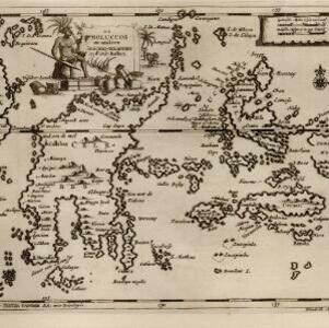
De Moluccos en andere Speceri-Eilanden in d'Oost-Indien

event1714

location_onIndonesia

Map of the ‘Spice Islands’ of maritime Southeast Asia, including the Maluku Islands. It is decorated with a drawing of an Asian man holding a large bird and a spear, and surrounded by baskets and boxes of goods of the spice trade.

Asiae nova descriptio

event1653

location_onBrunei, Cambodia, East Timor, Indonesia, Laos, Malaysia, Myanmar, Philippines, Southeast Asia, Singapore, Thailand, Vietnam

A mid-17th century map of Asia decorated with a border of drawings of Asian cities and Asian rulers, including the port of Bantam (Banten) at the western end of Java, and a portrait of ‘Rex Moluccae’ the ‘king’ of the Moluccas (Maluku Islands).

Insulæ Indiæ orientalis præcipuæ: in quibus Moluccæ celeberrimæ sunt

event1623

location_onBrunei, Cambodia, East Timor, Indonesia, Laos, Malaysia, Myanmar, Philippines, Singapore, Southeast Asia, Thailand, Vietnam

On the right of this map, Latin text held within an elaborate border notes that five of the Maluku Islands are located nearby—Ternate, Tidore, Moti, Makian and Bacan—which trade spices including clove, cinnamon, nutmeg and ginger to the world.

Insulæ Indiæ orientalis præcipuæ: in quibus Moluccæ celeberrimæ sunt

event1606

location_onBrunei, Cambodia, East Timor, Indonesia, Laos, Malaysia, Myanmar, Philippines, Singapore, Southeast Asia, Thailand, Vietnam

On the right of this map, Latin text held within an elaborate border notes that five of the Maluku Islands are located nearby—Ternate, Tidore, Moti, Makian and Bacan—which trade spices including clove, cinnamon, nutmeg and ginger to the world.

close