Search

Search Results

Isles Moluques

eventc.1748-1767

location_onEast Timor, Indonesia

The southern coasts of Sumbawa (‘Coinbava’) and Sumba (‘Sandet’), and most of the coast of New Guinea (‘Nouvelle Guinée’) are represented by a dotted line on this mid-18th century map, indicating that the exact coastlines were unknown at this time.

De landvoogdy van Amboina met de elf onderhoorige eylanden

event1726

location_onIndonesia

Although mainly a navigation map—with a rhumbline network and elevations of mountains—there are also many terrestrial details shown, such as settlements and mountains. The inset map of Hoeamohel details plantations and the cultivation of nut crops.

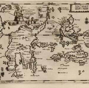
De Moluccos en andere Speceri-Eilanden in d'Oost-Indien

event1714

location_onIndonesia

Map of the ‘Spice Islands’ of maritime Southeast Asia, including the Maluku Islands. It is decorated with a drawing of an Asian man holding a large bird and a spear, and surrounded by baskets and boxes of goods of the spice trade.

Moluccæ insulæ

event1618

location_onIndonesia, East Timor

Unusually, north is located to the right of this early 17th century map of the Maluku Islands, rather than the top. The scale is shown on a stone monument. French text on the reverse describes Java.

close

  • Filter from 1618 to 1748

Current results range from 1618 to 1748