Search

Search Results

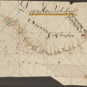
[De kust van Vietnam van Da Nang tot de monding van de Mekong]

event1750

location_onVietnam

Map of the coast of Tsiompa and Couchinchina (Vietnam) designed for navigation, with a rhumbline network and bathymetry (sea depth). The large area marked with crosses represents the Paracel Islands. The modern city of Da Nang is at the far right.

[Zuid-Chinese Zee]

event1686

location_onIndonesia, Malaysia, Thailand, Cambodia, Vietnam

Early navigation map of the South China Sea. The web of lines is a rhumbline network, while the numbers indicate sea depth (bathymetry), both used to aid navigation. A route around the Gulf of Thailand is marked with text and the dates 1643 and 1644.

close

  • Filter from 1686 to 1750

Current results range from 1686 to 1750