Search

Search Results

Archipel des Indes Orientales: qui comprend les Isles de la Sonde, Moluques et Philippines

event1750

location_onBrunei, Cambodia, East Timor, Indonesia, Malaysia, Philippines, Singapore, Southeast Asia, Thailand, Vietnam

This 18th century map of Southeast Asia by the French cartographer Gilles Robert de Vaugondy features the national borders of the Philippines in green, and of modern Indonesia in yellow. The Malay Peninsula and modern Cambodia and Vietnam are in red.

Asia Concinnata Secundum Observationes Academiæ Regalis Scientiarum et nonnullas alias, et juxta annotationes recentissimas

eventc.1750

location_onBrunei, Cambodia, East Timor, Indonesia, Laos, Malaysia, Myanmar, Philippines, Singapore, Southeast Asia, Thailand, Vietnam

This mid-18th century map of Asia features a note stating that there are new features on this map not seen on previous maps, and that this is not a mistake. The cartouche features a column of Asian people riding on horses and camels.

Asia Concinnata Secundum Observationes Academiæ Regalis Scientiarum et nonnullas alias, et juxta annotationes recentissimas

eventc.1750

location_onBrunei, Cambodia, East Timor, Indonesia, Malaysia, Laos, Myanmar, Philippines, Singapore, Southeast Asia, Thailand, Vietnam

This mid-18th century map of Asia features a note stating that there are new features on this map not seen on previous maps, and that this is not a mistake. The cartouche features a column of Asian people riding on horses and camels.

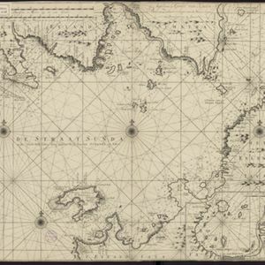
De Straat Sunda in de Oost-Indische Zee tussen de Eylanden Sumatra en Java

eventc.1750

location_onIndonesia

Chart of the Sunda Strait, focusing on bays and islands, and showing bathymetry (sea depth), anchor points, shoals and reefs, landmarks, and a rhumbline network, all to aid navigation. Includes an inset map of the bay of the city of Banten on Java.

A new and accurate map of the East India Islands: laid down according to the latest discoveries, and agreeable to the most approved maps & charts

event1750

location_onBrunei, Cambodia, East Timor, Indonesia, Laos, Malaysia, Myanmar, Vietnam, Thailand, Southeast Asia, Singapore, Philippines

This mid-18th century map of Southeast Asia includes written notes on goods produced and traded, geographical features, and wild animals found in each part of the region. The cartouche features a drawing of Asia with people, fields and palm trees.

Asia Concinnata Secundum Observationes Academiæ Regalis Scientiarum et nonnullas alias, et juxta annotationes recentissimas

eventc.1750

location_onBrunei, Cambodia, East Timor, Indonesia, Laos, Malaysia, Myanmar, Philippines, Singapore, Southeast Asia, Thailand, Vietnam

This mid-18th century map of Asia features a note stating that there are new features on this map not seen on previous maps, and that this is not a mistake. The cartouche features a column of Asian people riding on horses and camels.

Asia Concinnata Secundum Observationes Academiæ Regalis Scientiarum et nonnullas alias, et juxta annotationes recentissimas

eventc.1750

location_onBrunei, Cambodia, East Timor, Indonesia, Malaysia, Laos, Myanmar, Philippines, Singapore, Southeast Asia, Thailand, Vietnam

This mid-18th century map of Asia features a note stating that there are new features on this map not seen on previous maps, and that this is not a mistake. The cartouche features a column of Asian people riding on horses and camels.

De Straat Sunda in de Oost-Indische Zee tussen de Eylanden Sumatra en Java

eventc.1750

location_onIndonesia

Chart of the Sunda Strait, focusing on bays and islands, and showing bathymetry (sea depth), anchor points, shoals and reefs, landmarks, and a rhumbline network, all to aid navigation. Includes an inset map of the bay of the city of Banten on Java.

Partie de la nouvelle grande carte des Indes Orientales, contenant les isles Maldives, Ceylan, Malacca, Sumatra... les isles de Borneo, Iava, Celebes, Mindanao

eventc.1750

location_onBrunei, East Timor, Indonesia, Malaysia, Papua New Guinea, Philippines, Singapore

Map of maritime Southeast Asia, with mountains, forests and settlements represented pictorially. The lower part of the map, which had six inset maps, has been cut off and is missing.

Partie de la nouvelle grande carte des Indes Orientales, contenant les isles Maldives, Ceylan, Malacca, Sumatra... les isles de Borneo, Iava, Celebes, Mindanao

eventc.1750

location_onBrunei, East Timor, Indonesia, Malaysia, Papua New Guinea, Philippines, Singapore

Map of maritime Southeast Asia, with four inset maps of locations in the region: Surabaya, some of the Lesser Sumba Islands, and Buton and Muna islands of the coast of Sulawesi. Mountains, forests, settlements and fields are represented pictorially.

A new and accurate map of the East India Islands: laid down according to the latest discoveries, and agreeable to the most approved maps & charts

event1750

location_onBrunei, Cambodia, East Timor, Indonesia, Laos, Malaysia, Myanmar, Philippines, Singapore, Southeast Asia, Thailand, Vietnam

This mid-18th century map of Southeast Asia includes written notes on goods produced and traded, geographical features, and wild animals found in each part of the region.

Archipel des Indes Orientales: qui comprend les Isles de la Sonde, Moluques et Philippines

event1750

location_onBrunei, Cambodia, East Timor, Indonesia, Malaysia, Philippines, Singapore, Southeast Asia, Thailand, Vietnam

This 18th century map of Southeast Asia by the French cartographer Gilles Robert de Vaugondy features the national borders of the Philippines in green, and of modern Indonesia in yellow. The Malay Peninsula and modern Cambodia and Vietnam are in red.

close