Search

Search Results

Trade Routes in the Far East

event1894

location_onBrunei, Cambodia, Indonesia, Laos, Malaysia, Myanmar, Philippines, Singapore, Thailand, Vietnam

Map of stream ship trade routes around Southeast Asia. Rivers, railways, submarine telegraph cables, lighthouses (fixed, revolving and flashing), graving docks and coaling stations are marked. An inset map shows a railway route from Britain to Asia.

East Indies

event1855

location_onBrunei, Cambodia, East Timor, Indonesia, Laos, Malaysia, Myanmar, Philippines, Singapore, Southeast Asia, Thailand, Vietnam

Coloured borders are used to highlight the colonial territories of the British (red), Dutch (orange), Spanish (red) and Portuguese (blue) on this mid-19th century map of Southeast Asia. An inset map shows the island and strait of Singapore.

A chart of the Indian and Pacific Oceans with particular plans of the harbours

event1847

location_onBrunei, Cambodia, East Timor, Indonesia, Laos, Malaysia, Myanmar, Papua New Guinea, Philippines, Southeast Asia, Singapore, Thailand, Vietnam

Southeast Asia is shown on sheets two and three of this 12-sheet map of the Indian and Pacific oceans, including detailed inset maps of the straits of Singapore, Bangka, Gaspar and Sunda, with bathymetry (sea depth), shoals, reefs, anchorages etc.

Die Ostindischen Inseln

event1846

location_onBrunei, Cambodia, East Timor, Indonesia, Laos, Malaysia, Myanmar, Philippines, Singapore, Southeast Asia, Thailand, Vietnam

Map of Southeast Asia highlighting the colonial possessions of the Netherlands (Dutch East Indies), Spain (Philippines), Britain (Straits Settlements, Burma, part of Borneo) and Portugal (East Timor). From the German atlas ‘Stielers Handatlas’.

Ost-Indien mit den Inseln

eventc.1835

location_onBrunei, Cambodia, East Timor, Indonesia, Laos, Malaysia, Myanmar, Philippines, Singapore, Southeast Asia, Thailand, Vietnam

On this map of India and Southeast Asia, borders are outlined and cities underlined in different colours to show the colonial territories of the European powers. On Borneo, the names of indigenous peoples are listed (‘Dayak’s, Papua’s, Bugi’s’).

China, Birmah and Anam

event1835

location_onCambodia, Laos, Myanmar, Thailand, Vietnam, Philippines

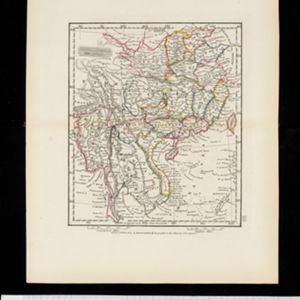
Coloured borders are used on this map to divide mainland Southeast Asia into empires and kingdoms. Mountains, rivers and major settlements are shown in land, with islands, shoals and reefs marked in the South China Sea.

Ost-Indien mit den Inseln

eventc.1835

location_onBrunei, Cambodia, East Timor, Indonesia, Laos, Malaysia, Myanmar, Philippines, Singapore, Southeast Asia, Thailand, Vietnam

On this map of India and Southeast Asia, borders are outlined and cities underlined in different colours to show the colonial territories of the European powers. On Borneo, the names of indigenous peoples are listed (‘Dayak’s, Papua’s, Bugi’s’).

Birman Empire

event1829

location_onMyanmar, Thailand, Laos, Vietnam, Cambodia

This map of the Burman Empire (Myanmar) features mountains, forests and rivers, as well as borders with Siam (Thailand) and Laos. Text notes how far up rivers boats can reach (‘Boats reach hither from the Sea’), ruby mines and rice fields.

Birman Empire

event1824

location_onCambodia, Myanmar, Thailand, Vietnam, Laos

This map of the Burman Empire (Myanmar) features mountains, forests and rivers, as well as borders with Siam (Thailand) and Laos. Text notes how far up rivers boats can reach (‘Boats reach hither from the Sea’), ruby mines and rice fields.

East Indies

eventc.1800-1899

location_onBrunei, Cambodia, East Timor, Indonesia, Laos, Malaysia, Myanmar, Philippines, Singapore, Southeast Asia, Thailand, Vietnam

Longitude is indicated in two different ways on this mid-18th century map: along the top border, it is shown in degrees (number of degrees east of London); more unusually, along the bottom border, it is shown in time (number of hours east of London).

Chart... Shewing the Connection and respective distances by Sea, between the principal harbours and Settlements in the East Indies

event1794

location_onThailand, Myanmar, Malaysia, Indonesia

Maritime routes had to be adjusted in response to the changing monsoon seasons, as is seen on this late 18th century map of the Indian Ocean. Drawings of the heads of children blowing—called ‘wind-heads’—are used to indicate wind direction.

close