Search

Search Results

Schetskaart van West-Seran (Vulgo Ceram) / Schetskaart van Oost- en Midden Seran

event1896

location_onIndonesia

Map of the island of Seram in the Maluku Islands, originally produced as two separate maps. Red lines show lines of communication of local people (referred to as ‘Alfoer’), with their tribe’s name. Muslim, Christian and Alfoer settlements are marked.

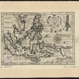
Insulae Indiae orientalis

event1634

location_onBrunei, Cambodia, East Timor, Indonesia, Laos, Malaysia, Myanmar, Philippines, Singapore, Southeast Asia, Thailand, Vietnam

On this early 17th century map of maritime Southeast Asia, the southern coast of Java ('Iava Maior') is represented by a dotted line, indicating that the exact coastline was unknown at this time.

close

  • Filter from 1634 to 1896

Current results range from 1634 to 1896