Search

Search Results

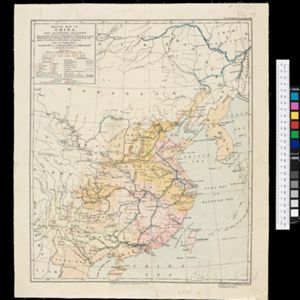
Sketch map of China and adjoining regions: showing the density of population, mineral resources, chief products, principal trade routes, existing and projected railways, and inland navigation

event1898

location_onMyanmar, Thailand, Vietnam

This map of China features a small part of northeastern Southeast Asia. Population density is shown, along with rivers, trade routes, tidal river navigation limits, railways (existing and suggested), and two coal mines in Tong-King (Vietnam).

Map of Eastern New Guinea: illustrating a paper by Sir Wm. MacGregor

event1897

location_onIndonesia, Papua New Guinea

Map of eastern New Guinea, showing the routes—mainly along rivers—explored by Sir William MacGregor, the administrator of British New Guinea. The borders with the German colonial territory (Kaiser-Wilhelmsland) and Dutch New Guinea are also marked.

Sketch map of the Malay States, Kelantan and Trengganu, to illustrate the Paper by Hugh Clifford

event1896

location_onMalaysia

Map of the east coast of the Malay Peninsula, showing the route taken along the rivers and coast by Hugh Clifford, who was the British Resident at Pahang at the time. In addition to rivers, significant mountains and settlements are marked.

The chief passes from Siam into Tavoi / The Siamese Malay States

event1895

location_onMyanmar, Thailand, Malaysia

Two maps of Siam (Thailand). The larger map shows routes through mountain passes from Siam to the city of Tavoi (Dawei, on the west coast of Myanmar). The smaller map is marked with trade routes around Lower Siam (Southern Thailand).

Map of the Johore Territory 1893

event1894

location_onMalaysia, Singapore

Map of the Malay state of Johor, and Singapore. The route of a proposed railway north from Johor Bahru is shown. Apart from rivers and mountains, much of the terrain is blank, with labels such as ‘Unexplored Hill Country’ or ‘Dense Jungle and Swamp’.

Sketch map of Baram District, Sarawak, Borneo

event1893

location_onMalaysia, Indonesia, Brunei

Map of the Baram District, Borneo, by the British ethnologist Charles Hose, divided into territories of indigenous peoples: Malanaus, Kayans, Kenniahs, Orang-Bukits, Sibops, Madangs, Kalabits, Balaits, Tutongs, Kadayans and Malays.

Map of the Kingdom of Siam and its dependencies

event1888

location_onCambodia, Laos, Malaysia, Myanmar, Thailand, Vietnam

Map of the Kingdom of Siam, featuring mountains, rivers and villages, and surrounded by a yellow border (the border with Upper Burma and China in the north is undefined). The southern part of Siam is shown on an inset map of the Malay Peninsula.

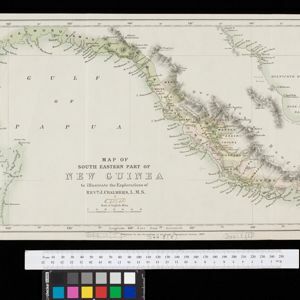
Map of South Eastern part of New Guinea: to illustrate the explorations of Rev. J. Chalmers, L.M.S.

event1887

location_onPapua New Guinea

Map of the southeast coast of British New Guinea, divided into administrative regions, with the northern regions left mostly blank. Based on the explorations of the Scottish missionary James Chalmers.

Burma: with parts of India, China, and Siam

event1886

location_onMyanmar, Laos, Thailand

Map of Burma labelled with indigenous peoples (uppercase red text) and products (salt, copper, tea, rubies, coal, rubber, petroleum, marble, jade, silver) of each area. It also marks two journeys by the explorer J. Annan Bryce, and proposed railways.

close

  • Filter from 1886 to 1898

Current results range from 1886 to 1898