Search

Search Results

Schetze van de stad Batavia, voorsteden en Chineesche kamp, dienende ter aanwijzing der rivieren en grachten... moeten worden uitgediept, uitgegraven of gedempt

event1898

location_onIndonesia

Plan of the city of Batavia (Jakarta) and its suburbs. Based on a report on health conditions in the city, it shows where the rivers and canals need to be deepened, excavated or filled in.

Situatie plan van Batavia met desselfs stranden en ommelanden tot de buiten posten Angiol, Noortwijk, Rijswijk, de Kelling , Ankee en de Fluit

event1898

location_onIndonesia

Plan of the city of Batavia (Jakarta) with its suburbs and surrounding areas. Artillery batteries are marked on the beaches, and there is a detailed legend identifying places on the map. This is a copy of an original 1797 map.

De stad Batavia met derzelver omstreken: Geteekend in 1826

event1898

location_onIndonesia

The city of Batavia (Jakarta) with its port and castle is to the north (right side of the map). Koningsplein (Merdeka Square), a large area of rice paddies, graveyards and villages can be seen to the south (left). Copied from a c.1826 map.

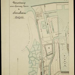
Voorontwerp eener spoorweghaven te Soerabaia

event1898

location_onIndonesia

Spread over four sheets, this is a detailed hand-drawn plan for railway and tramway lines at the port of Soerabaia (Surabaya, East Java). It includes a railway station, commercial areas, housing, customs, warehouses, offices and government buildings.

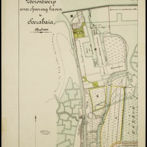
Voorontwerp eener spoorweghaven te Soerabaia

event1897

location_onIndonesia

Spread over four sheets, this is a detailed hand-drawn plan for railway and tramway lines at the port of Soerabaia (Surabaya, East Java). It includes a railway station, commercial areas, housing, customs, warehouses, offices and government buildings.

Atlas van Nederlandsch Oost-Indië

eventc.1897-1904

location_onIndonesia

Very detailed atlas of the entire Dutch East Indies, over 16 map sheets, with a cover and overview map. Includes topographic maps, inset maps of cities and islands, and maps featuring land and sea routes, languages, geology, colonial territory etc.

Kaart van den vierkanten paal (I en II) gouvernements grondgebied te Sintang

event1888

location_onIndonesia

The Kapoewas (Kapuas) and Melawi rivers converge on this map of the town of Sintang, Borneo. The town lines the river banks, and is surrounded by fields, forest and marshland. Arrows on the rivers mark the direction of their flow.

Topographische kaart der residentie Pasoeroean

event1887

location_onIndonesia

The residency of Pasoeroean (Pasuruan), East Java, featuring crops (coffee, cinchona (kina), rice, alang-alang, bamboo) and fishing ponds. Two inset maps: a triangulation map, and a map of distances between settlements by various types of transport.

Kaart van het Zuidwestelijk gedeelte van het landschap Mampawah, residentie Wester-afdeeling van Borneo

event1887

location_onIndonesia

Map of the crops—coconut, alang-alang, rice, nipa palm, bamboo—grown along the Mempawah River (west coast of Borneo). There are also large areas of swampy forest, Malay mosques, shrines and graveyards, and Chinese villages, temples and graveyards.

De Groote Siamse Rievier Me-Nam, ofte Moeder der Wateren: In haren loop met de in vallende Spruyten Verbeeld

event1726

location_onThailand

Map of the Me-nam River (Chao Phraya River) with the city of Ayutthaya (labelled ‘Siri India’) in the centre. Its mouth at the Gulf of Thailand is to the left. Over 100 buildings, towns and other places are shown pictorially and listed in the legend.

close

  • Filter from 1726 to 1898

Current results range from 1726 to 1898