Search

Search Results

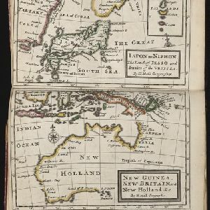
Iapon or Niphon the land of Iesso and Straits of the Vries / New Guinea, New Britain, and New Holland &c.

event1732

location_onEast Timor, Indonesia, Papua New Guinea

The London-based cartographer Herman Moll (1654?–1732) created this map of New Guinea and the neighbouring islands of maritime Southeast Asia. It shows that in the 1730s, the details of New Guinea and Australia (‘New Holland’) were uncertain.

The principal islands of the East-Indies: explaining what belongs to England, Spain and Holland &c.

eventc.1732

location_onBrunei, Cambodia, East Timor, Indonesia, Philippines, Malaysia, Thailand, Vietnam, Singapore, Southeast Asia

The letters ‘E’ or ‘D’ are marked after place names to indicate if they are English or Dutch colonial possessions: e.g. ‘Marleborough Fort E’ on Sumatra or ‘Concordia Fort D’ on Timor. The Philippines are labelled ‘to Spain’.

The principal islands of the East-Indies: explaining what belongs to England, Spain and Holland &c.

event1732

location_onBrunei, Cambodia, East Timor, Indonesia, Philippines, Malaysia, Thailand, Vietnam, Singapore, Southeast Asia

The letters ‘E’ or ‘D’ are marked after place names to indicate if they are English or Dutch colonial possessions: e.g. ‘Marleborough Fort E’ on Sumatra or ‘Concordia Fort D’ on Timor. The Philippines are labelled ‘to Spain’.

close