Search

Search Results

Kaart van het gebied bezet in Groot-Atjèh

event1898

location_onIndonesia

A six-sheet map of Groot-Atjèh (Aceh, northern Sumatra) focusing on areas occupied during the Aceh War (1873–1904) between the Sultanate of Aceh and Dutch colonists. It shows military positions and fortifications, buildings, routes and crops.

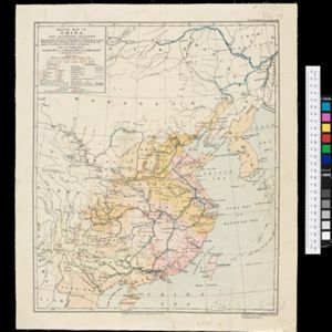
Sketch map of China and adjoining regions: showing the density of population, mineral resources, chief products, principal trade routes, existing and projected railways, and inland navigation

event1898

location_onMyanmar, Thailand, Vietnam

This map of China features a small part of northeastern Southeast Asia. Population density is shown, along with rivers, trade routes, tidal river navigation limits, railways (existing and suggested), and two coal mines in Tong-King (Vietnam).

Noord-Celebes

event1898

location_onIndonesia

A late 19th century map of the Minahasa Peninsula, northern Celebes (Sulawesi), marked with the locations of mines (‘mÿnen’). The red borders indicate areas for ‘mijnbouwkundig onderzoek [mining research]’.

A map of the Malay Peninsula

event1898

location_onMalaysia, Singapore, Thailand

Map of the Malay Peninsula showcasing the Straits Settlements in pink, the Federated Malay States in red, and Siamese states in yellow. A table of common words in English, Malay and Siamese is included. Only four of six sheets are available.

Burma with parts of India, China and Siam

event1888

location_onMyanmar, Laos, Thailand

Map of Burma used as advertising by a clothing shop in Rangoon (Yangon, Myanmar). There is a calendar with each day marked with an historic event. The map is labelled with indigenous peoples (uppercase red text) and products of each area.

close