Search

Search Results

Carta secon[d]a generale del'Asia

event1646

location_onIndonesia, East Timor, Philippines

This mid-17th century map of the Philippines, Celebes (Sulawasi), Maluku Islands and New Guinea has some inaccuracies, particularly in the shape of Celebes and New Guinea. However, the many Philippine islands are portrayed relatively accurately.

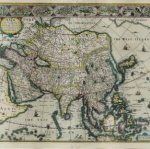
Asia with the islands adioyning described, the atire of the people, & townes of importance

eventc.1646-1657

location_onBrunei, Cambodia, East Timor, Indonesia, Laos, Malaysia, Myanmar, Philippines, Singapore, Southeast Asia, Thailand, Vietnam

This map is illustrated with drawings of Asian people wearing traditional clothing, including representatives of Sumatra, Java and the Maluku Islands. There are also drawings of important ports such as Bantam (Banten) at the western end of Java.

Asia recens summa cura delineata

eventc.1646-1657

location_onBrunei, Cambodia, East Timor, Indonesia, Laos, Malaysia, Myanmar, Philippines, Singapore, Southeast Asia, Thailand, Vietnam

A map of Asia decorated with illustrations of sea monsters, strange creatures and ships. There is Latin text on the back of the map describing Asia.

close