Search

Search Results

Hyetographic or rain map of the World

event1849

location_onBrunei, Cambodia, East Timor, Indonesia, Malaysia, Laos, Myanmar, Papua New Guinea, Philippines, Singapore, Southeast Asia, Thailand, Vietnam

A world map, including Southeast Asia, showing rainfall information (darker shading indicates greater rainfall). Southeast Asia lies in the ‘Zone of the Periodical Rains’, and is marked with monsoons and ‘Electrical Explosions’.

A chart of the Indian and Pacific Oceans with particular plans of the harbours

event1847

location_onBrunei, Cambodia, East Timor, Indonesia, Laos, Malaysia, Myanmar, Papua New Guinea, Philippines, Southeast Asia, Singapore, Thailand, Vietnam

Southeast Asia is shown on sheets two and three of this 12-sheet map of the Indian and Pacific oceans, including detailed inset maps of the straits of Singapore, Bangka, Gaspar and Sunda, with bathymetry (sea depth), shoals, reefs, anchorages etc.

Algemeene Kaart van Nederlandsch Oostindie

event1842

location_onEast Timor, Indonesia, Malaysia, Singapore

This detailed map of the Dutch East Indies in the mid-19th century is spread over eight sheets, plus a cover sheet showing the whole area. There are numerous inset maps of islands, bays, cities etc.

Karte von der Insel Sumatra

event1837

location_onMalaysia, Indonesia, Singapore

Based on surveys by Sir Stamford Raffles, this German map of Sumatra focuses on the navigation of coasts and straits, with bathymetry (sea depth), anchor points, shoals and reefs marked, including on inset maps of Singapore and the Bangka Strait.

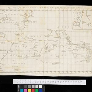
A general chart of the Atlantic and Indian oceans, with the situation & plan of Pulo Peenang or Price of Wales's Island / Plan of the Strait within Poolo Pinang

event1788

location_onMalaysia, East Timor, Indonesia, Papua New Guinea, Singapore

Two maps. One features most of the world, but with Borneo, Philippines and most of mainland Southeast Asia missing, though there is an inset map of Penang. The other is a navigation map of the strait at Penang, with bathymetry and elevations.

close

  • Filter from 1788 to 1849

Current results range from 1788 to 1849