
Search Results


Mapa de las Yslas Philipinas
1744
Indonesia, Philippines
First published in 1734, and commonly known as the ‘Velarde map’, this map by the Spanish cartographer Pedro Murillo Velarde is regarded as the first important map of the Philippines. This is a later version, lacking 12 drawings on the map's sides.

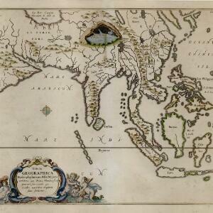
India orientalis, cum adjacentibus insulis
1740
Brunei, Cambodia, East Timor, Indonesia, Laos, Malaysia, Myanmar, Philippines, Singapore, Southeast Asia, Thailand, Vietnam
This mid-18th century map of Asia features a drawing of religious imagery: Asian people are seen making offerings to two figures, including the Greek god Poseidon (or the Roman god Neptune), and kneeling as cherubs descend from the sky.

Asiae recentissima delineatio, qua Status et Imperia totius Orientis unacum Orientalibus Indiis exhibentur
1716
Vietnam, Myanmar, Papua New Guinea, Philippines, Singapore, Southeast Asia, Thailand, Malaysia, Laos, Indonesia, East Timor, Cambodia, Brunei
This map's cartouche features an illustration of three men bowing before an enthroned ruler. A second image is of a procession where a horned four-armed humanoid creature is being carried on poles by two bearers, while musicians follow behind.

Exactissima Asiae delineatio, in praecipuas regiones, ceterasq partes divisa
1705
Brunei, Cambodia, East Timor, Indonesia, Laos, Myanmar, Malaysia, Philippines, Singapore, Southeast Asia, Thailand, Vietnam
The illustration on this map highlights the wealth of the Asian trade routes, with merchants wearing colourful and elaborate robes presenting valuable treasures to a royal figure. A monkey, tortoise and camel emphasise the 'exoticism' of Asia.

Exactissima Asiae delineatio, in praecipuas regiones, ceterasq partes divisa
1702
Brunei, Cambodia, East Timor, Indonesia, Laos, Malaysia, Myanmar, Philippines, Singapore, Southeast Asia, Thailand, Vietnam
The illustration on this map highlights the wealth of the Asian trade routes, with merchants wearing colourful and elaborate robes presenting valuable treasures to a royal figure. A monkey, tortoise and camel emphasise the 'exoticism' of Asia.

Platte globus van hemel en aarde noyt alsoo gesien waar op heel licht kan geleert worden d'loop des hemels en zee-vaart op alle polus-hooghten
1697
Brunei, Cambodia, Indonesia, Laos, Malaysia, Myanmar, Philippines, Southeast Asia, Thailand, Vietnam, Singapore, East Timor
A richly illustrated circular map of the world, surrounded by a ring of stars and sky, and spread over four sheets. The corners contain drawings of Atlas and Hercules holding the Earth on their shoulders, and of various philosophers and astronomers.
Tabula Geographica Hydrophylacium Asiae Majoris exhibens, quo Omnia Flumina sive proximè sive remotè per occultos meandros Originem suam sortiuntur
1665
Brunei, Cambodia, Indonesia, Laos, Malaysia, Myanmar, Philippines, Singapore, Southeast Asia, Thailand, Vietnam
This map by Athanasius Kircher shows the ‘hydrophylacium’ of Asia, a mythical subterranean ocean that Kircher thought fed rivers and caused tides. Illustrations of Neptune, the god of the sea, and cherubs playing in water continue the aquatic theme.

Asia recens summa cura delineata
c.1646-1657
Brunei, Cambodia, East Timor, Indonesia, Laos, Malaysia, Myanmar, Philippines, Singapore, Southeast Asia, Thailand, Vietnam
A map of Asia decorated with illustrations of sea monsters, strange creatures and ships. There is Latin text on the back of the map describing Asia.

India orientalis et insulæ adiecentes
1638
Brunei, Cambodia, East Timor, Indonesia, Laos, Malaysia, Myanmar, Philippines, Singapore, Southeast Asia, Thailand, Vietnam
First published in Johann Ludwig Gottfried's ‘Newe Archontologia Cosmica’ in 1638, this map was based on a 1634 map by Willem Janszoon Blaeu. The cartouche features drawings of two men in ‘eastern’ clothing, holding septres, a sword and a shield.

Asia: ex magna orbis terre descriptione Gerardi Mercatoris desumpta, studio & industria G.M. Iunioris
1630
Brunei, Cambodia, East Timor, Indonesia, Laos, Malaysia, Myanmar, Philippines, Singapore, Southeast Asia, Thailand, Vietnam
Originally published in Gerardus Mercator's ‘Atlas Sive Cosmographicae Meditationes de Fabrica Mundi et Fabricati Figura’ (1595), the title of which was the first use of the word ‘atlas’ to refer to a collection of maps. This is a 1630 reprint.

Asia: ex magna orbis terre descriptione Gerardi Mercatoris desumpta, studio et industria G.M. Iunioris
c.1613-1630
Brunei, Cambodia, East Timor, Indonesia, Laos, Malaysia, Myanmar, Philippines, Singapore, Southeast Asia, Thailand, Vietnam
Although quite detailed for an early 17th century map of Asia, there are some inaccuracies in the representation of the islands of Southeast Asia, particularly Java (labelled 'Iaua maior'), Borneo (Burne), Sulawesi (Celebes) and the Maluku Islands.
- Filter from 1565 to 1748
- Borneo26
- [remove]Mindanao26
- Sumatra24
- Java23
- Sulawesi21
- Malay Peninsula18
- Pegu18
- Celebes17
- Western New Guinea16
- Camboia13
- Malacca13
- Maluku Islands12
- more Detailed Location »
- [remove]River26


