Search Results

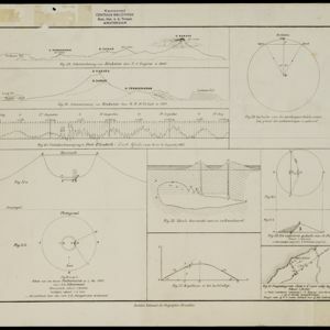
[Grafieken en tekeningen betreffende de uitbarsting van de Krakatau in 1883]
1883
Indonesia
A series of graphs and drawings about the 1883 eruption of the Krakatoa volcano. Includes elevation views from 1849 and 1880, a globe showing where the eruption was heard, a sketch of the crater of one of the cones, and a cross-section of a volcano.

Reduzirte Karte vom Sunda- oder Borneo-Meere
1835
Indonesia, Malaysia
A navigation map of the Java Sea and Sunda Islands, with bathymetry (sea depth), maritime routes, shoals and reefs, and elevations (side views of terrestrial landmarks). Inset maps feature the bay at Batavia and the straits between the Sunda Islands.

Reduzirte Karte vom Sunda- oder Borneo-Meere
1835
Malaysia, Indonesia
A navigation map of the Java Sea and Sunda Islands, with bathymetry (sea depth), maritime routes, shoals and reefs, and elevations (side views of terrestrial landmarks). Inset maps feature the bay at Batavia and the straits between the Sunda Islands.

Reduzirte Karte vom Sunda- oder Borneo-Meere
1835
Malaysia, Indonesia
A navigation map of the Java Sea and Sunda Islands, with bathymetry (sea depth), maritime routes, shoals and reefs, and elevations (side views of terrestrial landmarks). Inset maps feature the bay at Batavia and the straits between the Sunda Islands.

Reduzirte Karte vom Sunda- oder Borneo-Meere
1835
Malaysia, Indonesia
A navigation map of the Java Sea and Sunda Islands, with bathymetry (sea depth), maritime routes, shoals and reefs, and elevations (side views of terrestrial landmarks). Inset maps feature the bay at Batavia and the straits between the Sunda Islands.

A new chart shewing the navigation through the Strait of Sunda to Batavia
1815
Indonesia
Navigation chart of the Sunda Strait, with sea depth, anchor points, shoals and other obstructions. Includes many bays, with four highlighted on inset maps. Partly based on writings of Captain Krusenstern whose 1806 route through the strait is shown.


