location_onBrunei, East Timor, Indonesia, Malaysia, Philippines, Singapore, Thailand
Two maps of the Dutch East Indies: one of the whole region, and one of Java alone. Both are divided into administrative regions—e.g. Java is divided into regencies—with coloured borders.
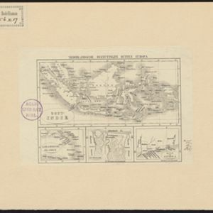
Nederlandsche bezittingen buiten Europa
eventc.1850
location_onBrunei, East Timor, Indonesia, Malaysia, Singapore
Map of the East Indies, showing Dutch colonial territory (Dutch East Indies) in the mid-19th century. Three inset maps show other Dutch territories outside Southeast Asia.
Nederlandsch Oost-Indië / Java
eventc.1850
location_onBrunei, East Timor, Indonesia, Malaysia, Philippines, Singapore, Thailand
Two maps of the Dutch East Indies: one of the whole region, and one of Java alone. Both are divided into administrative regions—e.g. Java is divided into regencies—with coloured borders.
Nederlandsche bezittingen buiten Europa
eventc.1850
location_onBrunei, East Timor, Indonesia, Malaysia, Singapore
Map of the East Indies, showing Dutch colonial territory (Dutch East Indies) in the mid-19th century. Three inset maps show other Dutch territories outside Southeast Asia.