Search

Search Results

W. & A.K. Johnston's sheet of maps to illustrate the Caroline islands dispute between Germany and Spain

event1885

location_onSoutheast Asia, Papua New Guinea, Indonesia, Philippines, Malaysia, East Timor

Three maps of the Caroline Islands. One shows colonised areas in Southeast Asia: Dutch East Indies; British North Borneo, British New Guinea; German New Guinea; Philippines (Spain); Portuguese Timor. The route of the Challenger expedition is marked.

Reduzirte Karte von den Philippinen und den Sulu Inseln

event1884

location_onPhilippines, Malaysia, Indonesia

Maritime map of the Philippines, with inset maps of bays showing bathymetry (sea depth), shoals, reefs and anchor points. There is also an inset map of Taal Volcano, and elevations (side views of terrestrial landmarks like mountains and islands).

Reduzirte Karte von den Philippinen und den Sulu Inseln

event1832

location_onMalaysia, Indonesia, Philippines

Maritime map of the Philippines, with inset maps of bays showing bathymetry (sea depth), shoals, reefs and anchor points. There is also an inset map of Taal Volcano, and elevations (side views of terrestrial landmarks like mountains and islands).

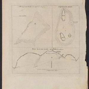
A dangerous shoal seen Septr. the 28, 1767 (Joseph Freewills Islands)

event1773

location_onPhilippines, Indonesia

These three maps are marked with shoals, rocks, water depth, safe entry points, and anchorage locations, to help ships safely anchor. The sites include the Joseph Freewill Islands (Mapia Atoll, Indonesia) and the coast of Mindanao in the Philippines.

Exactissima Asiae delineatio, in praecipuas regiones, ceterasq partes divisa

event1705

location_onBrunei, Cambodia, East Timor, Indonesia, Laos, Myanmar, Malaysia, Philippines, Singapore, Southeast Asia, Thailand, Vietnam

The illustration on this map highlights the wealth of the Asian trade routes, with merchants wearing colourful and elaborate robes presenting valuable treasures to a royal figure. A monkey, tortoise and camel emphasise the 'exoticism' of Asia.

Exactissima Asiae delineatio, in praecipuas regiones, ceterasq partes divisa

event1702

location_onBrunei, Cambodia, East Timor, Indonesia, Laos, Malaysia, Myanmar, Philippines, Singapore, Southeast Asia, Thailand, Vietnam

The illustration on this map highlights the wealth of the Asian trade routes, with merchants wearing colourful and elaborate robes presenting valuable treasures to a royal figure. A monkey, tortoise and camel emphasise the 'exoticism' of Asia.

close