Search

Search Results

No. 4 preliminary chart of the principal triangulation of the Mandalay meridional series

event1893

location_onMyanmar

A triangulation map of part of Upper Burma (Myanmar), showing nine locations (‘hill stations’) joined with straight lines to create a triangulation network. Each hill station’s latitude and longitude, height above sea level, and description is given.

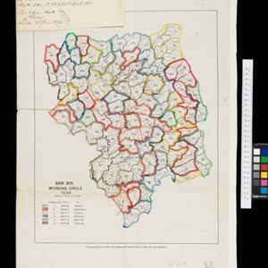
Baw Bin working circle: Teak

event1891

location_onMyanmar

A map of a teak forest in Baw Bin, Burma (Myanmar) from the late 19th century. It is a ‘working circle’, a plan that divides the forest up into smaller areas so they can be worked separately. The areas are colour-coded, and given a time period.

Sketch map showing forest reserves (sanctioned and proposed) in the Pegu and Tenasserim Divisions of British Burma

event1881

location_onMyanmar

Map of forest reserves—sanctioned and proposed—on the west coast of British Burma (Myanmar). The map also shows rivers, including the Irrawaddy River, and the railway from Rangoon (Yangon) to Prome (Pyay).

close

  • Filter from 1881 to 1893

Current results range from 1881 to 1893