Search

Search Results

Stanford's Library Map of Asia

event1891

location_onBrunei, Cambodia, East Timor, Indonesia, Laos, Malaysia, Myanmar, Philippines, Singapore, Southeast Asia, Thailand, Vietnam

Southeast Asia is on sheet four of this map. British colonial territory—British Burma, the Straits Settlements, Sarawak, British North Borneo—is highlighted in red, with the Dutch East Indies, Spanish Philippines and Portuguese East Timor also shown.

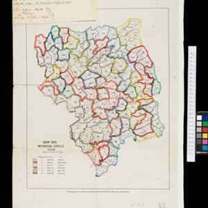
Baw Bin working circle: Teak

event1891

location_onMyanmar

A map of a teak forest in Baw Bin, Burma (Myanmar) from the late 19th century. It is a ‘working circle’, a plan that divides the forest up into smaller areas so they can be worked separately. The areas are colour-coded, and given a time period.

Map to show lines of advance on Manipur

event1891

location_onMyanmar

Map of three routes taken by British troops through the mountains to the Indian city of Manipur (Imphal) during the Anglo-Manipur War of 1891. The map includes part of Burma to the east.

close