Search

Search Results

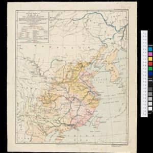
Sketch map of China and adjoining regions: showing the density of population, mineral resources, chief products, principal trade routes, existing and projected railways, and inland navigation

event1898

location_onMyanmar, Thailand, Vietnam

This map of China features a small part of northeastern Southeast Asia. Population density is shown, along with rivers, trade routes, tidal river navigation limits, railways (existing and suggested), and two coal mines in Tong-King (Vietnam).

Map of the Burman Empire including also Siam, Cochin-China, Ton-king and Malaya

event1842

location_onVietnam, Myanmar, Malaysia, Indonesia, Thailand, Laos, Cambodia, Brunei, Singapore

Regional borders are colour-coded on this mid-19th century map of mainland Southeast Asia, with British colonial territory in red (including part of the Burman Empire, the Straits Settlements, and Sarawak on Borneo).

Birmanen Reich mit Anam, Siam & Cochin China

eventc.1840

location_onCambodia, Indonesia, Laos, Malaysia, Myanmar, Singapore, Thailand, Vietnam

This mid-19th century map of mainland Southeast Asia is divided into regions with colour-coded borders. The Birman Empire/Birmah (Myanmar) is the most detailed, with 10 provinces marked and listed in the map’s legend.

Map of the Burman Empire including also Siam, Cochin-China, Ton-king and Malaya

event1832

location_onVietnam, Myanmar, Malaysia, Indonesia, Thailand, Laos, Cambodia, Brunei, Singapore

Regional borders are colour-coded on this mid-19th century map of mainland Southeast Asia, with British colonial territory in red (including part of the Burman Empire, the Straits Settlements, and Sarawak on Borneo).

close