
Search Results


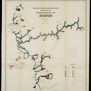
Bijdrage tot eene geologische kaart der residentie Westerafdeeling van Borneo
1858
Indonesia
A geological map of western Borneo made by a mine engineer, showing the types of soil, coal, clay, and rock (limestone, sandstone, granite, basalt), as well as gold, diamonds, tin, copper and iron found along the rivers.
- Filter from 1858 to 1899
- Borneo3
- Dutch East Indies3
- [remove]Residentie Westerafdeeling van Borneo3
- British North Borneo2
- Britsch Noord-Borneo2
- Kalimantan2
- Residentie Zuider- en Zuiderafdeeling van Borneo2
- Sarawak2
- Serawak2
- West Kalimantan1


