Search

Search Results

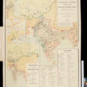
Dislocations-Karte der Indo-britischen Streitkräfte in Ost-Indien und der Russischen Streitkräfte in Asien

event1892

location_onMyanmar

Four maps showing the locations of British and Russian military units in Asia, including British and Indian (Madras Army) troops in Burma (Myanmar). Extensive legends identify individual regiments, battalions etc.

New Sketch Map of the Protected Malay State of Perak

event1892

location_onMalaysia

Map of the state of Perak (Malay Peninsula) with a table of statistics: area, population, road/railway/river lengths, revenue, tin exports. Gold and tin mines are marked, and the Straits Settlements are highlighted in red.

New sketch map of the protected Malay State of Perak

event1892

location_onMalaysia

Map of state of Perak (Malay Peninsula) with a table of statistics: area, population, road/railway/river lengths, revenue, tin exports. Straits Settlements highlighted red. Someone has added handwritten travel times/distances by steamer/road/train.

Schutzgebiet der Neu-Guinea-Kompanie

eventc.1892-1893

location_onIndonesia, Papua New Guinea

Very detailed six-sheet map of eastern New Guinea, with numerous inset maps of bays and islands, and other inset maps covering ethnography, explorers of the region, marine routes across the Pacific Ocean, cannibalism, missionaries activity etc.

Stanford's Library Map of Asia

event1891

location_onBrunei, Cambodia, East Timor, Indonesia, Laos, Malaysia, Myanmar, Philippines, Singapore, Southeast Asia, Thailand, Vietnam

Southeast Asia is on sheet four of this map. British colonial territory—British Burma, the Straits Settlements, Sarawak, British North Borneo—is highlighted in red, with the Dutch East Indies, Spanish Philippines and Portuguese East Timor also shown.

Kaart van een gedeelte van Borneo: met aanwijzing van de grens tusschen het Nederlandsch gebied en dat van het Britsche Protectoraat

event1891

location_onIndonesia, Malaysia, Myanmar

Map marking the border (in orange) agreed between British and Dutch territory on Borneo in 1891. Alternative borders are shown: according to the Dutch (blue), according to the British North Borneo Society (yellow) and proposed by the British (green).

Kaart van een gedeelte van Borneo: met aanwijzing van de grens tusschen het Nederlandsch gebied en dat van het Britsche Protectoraat

event1891

location_onIndonesia, Malaysia

Map marking the border (in orange) agreed between British and Dutch territory on Borneo in 1891. Alternative borders are shown: according to the Dutch (blue), according to the British North Borneo Society (yellow) and proposed by the British (green).

Map to illustrate Report on Frontier Expedition 1890-91

event1891

location_onMyanmar

Map of the border region between northeast Burma (Myanmar) and China's Yunnan Province, spread over two sheets. The Burma side is more detailed, featuring mountains, rivers and settlements, as well as roads and trade routes.

Map to show lines of advance on Manipur

event1891

location_onMyanmar

Map of three routes taken by British troops through the mountains to the Indian city of Manipur (Imphal) during the Anglo-Manipur War of 1891. The map includes part of Burma to the east.

Kaart van het eiland Flores

event1890

location_onIndonesia

Hand-drawn map of Flores in the Lesser Sunda Islands, with extensive written notes describing the island, e.g. the interior is unknown to Europeans; the names of the main Christian villages are underlined.

South eastern frontier

eventc.1890-1906

location_onMyanmar, Thailand

Very detailed large-scale map of the southeast border of Burma (Myanmar) and Siam (Thailand), divided into districts. Spread over multiple sheets, seems incomplete (some sheets appear more than once, probably from different versions of the same map).

Malay, or East Indian Archipelago, with Burmah, Siam &c.

event1887

location_onBrunei, Cambodia, East Timor, Indonesia, Laos, Malaysia, Myanmar, Philippines, Singapore, Southeast Asia, Thailand, Vietnam

On this map of Southeast Asia, numerous small islands, shoals and reefs are marked and named, especially in the South China Sea and around the Sunda and Maluku islands. Submarine cables to carry telegraph messages around the region are also shown.

close