
Search Results


Algemeene Kaart van het Gouvernement der Moluksche Eilanden
1855
Indonesia
Map of the Dutch colonial administrative regions (residencies) of the Moluccas (Maluku Islands), with Celebes (Sulawesi) and New Guinea. (From ‘Algemeene Atlas van Nederlandsche Indie [General Atlas of the Dutch East Indies]’.)

Kaart van Ternate, Halmaheira en Omringende Eilanden
1854
Indonesia
Map of Halmahera and other of the northern Maluku islands, colour-coded by their administrative region, with the seas and passages between them named. (From ‘Algemeene Atlas van Nederlandsche Indie [General Atlas of the Dutch East Indies]’.)


Kaart der Nederlandsche bezittingen in Oostindien = Possessions hollanaises aux Indes Orientales
1840
Brunei, East Timor, Indonesia, Malaysia, Singapore
Map of Dutch colonial territory in Southeast Asia, including the administrative areas of Java and Madura. Two maritime routes are marked from Batavia to the Maluku Islands: of the brig ‘Douga’ in 1825, and by Baron Godert van der Capellen in 1824.

Algemeene kaart van Nederlandsch Oostindie
c.1839-1855
East Timor, Indonesia, Malaysia, Singapore
This map of the Dutch East Indies is spread over eight sheets, with a hand-drawn cover sheet showing the whole area. There are numerous inset maps of islands, bays, cities etc. Two of the inset maps have a replacement map pasted over them.

Nieuwe en naukeurige kaart der Oost-Indische Eilanden
c.1770
Brunei, Cambodia, East Timor, Indonesia, Laos, Malaysia, Myanmar, Philippines, Singapore, Southeast Asia, Thailand, Vietnam
Some regions on this map of Southeast have a descriptive label: Sumatra is described as having mines of gold, silver, iron, and sulphur; and elephants, tigers, rhinoceroses, dragons and crocodiles. Gilolo has rice, sago and turtles. Ambon has nutmeg.
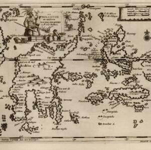
De Moluccos en andere Speceri-Eilanden in d'Oost-Indien
1714
Indonesia
Map of the ‘Spice Islands’ of maritime Southeast Asia, including the Maluku Islands. It is decorated with a drawing of an Asian man holding a large bird and a spear, and surrounded by baskets and boxes of goods of the spice trade.

Exacta & accurata delineatio cùm orarum maritimarum tùm etiam locorum terrestrium quae in regionibus China, Cauchinchina, Camboia sive Champa, Syao, Malacca, Aracan & Pegu
1596
Brunei, Cambodia, East Timor, Indonesia, Laos, Malaysia, Myanmar, Philippines, Singapore, Southeast Asia, Thailand, Vietnam
Unusually, north is located to the left of this map of East Asia, rather than the top. The text notes that shallows and reefs are marked, and that the map is based on the explorations of Portuguese ships. Illustrations include sea monsters and ships.


