Search

Search Results

Map of South-Eastern Asia and Northern Australia: showing the districts in Annam and Tonquin which France proposes to annex and to place under a Protectorate, the portion of New Guinea proposed to be acquired by Queensland, and the districts affected by the volcanic eruptions in Java

event1883

location_onSoutheast Asia, Singapore, Thailand, East Timor, Vietnam, Brunei, Cambodia, Indonesia, Laos, Malaysia, Myanmar, Papua New Guinea, Philippines

This 1883 map shows European colonial territories in Southeast Asia. An inset map details the proposed French annexation of Tonquin, Annam and Cochin China (modern Vietnam). International telegraph lines are also marked.

Overzichtskaart en bladwijzer der afdeeling Banjoewangi

event1883

location_onIndonesia

This overview map of Banjoewangi (Banyuwangi Regency, East Java) features mountains, rivers and the Bali Strait. Distances between settlements are marked along the roads, and there is a small inset map of the city of Banjoewangi.

Kaart van Straat Soenda

event1883

location_onIndonesia

The coloured areas on this map indicate the coastal regions that flooded after the 1883 Krakatoa volcanic eruption. Krakatoa is shown in the centre of the Sunda Strait, between Sumatra and Java.

Moekim Lepong

event1883

location_onIndonesia

Map of Lepong (Leupung) in Aceh, northern Sumatra, surrounded by paddy fields and mountains. There are handwritten corrections and additions in red ink, and an inset map of the mouth of the Kroeng Lepong river showing it four years earlier in 1879.

Topographische kaart der residentie Batavia

eventc.1882-1883

location_onIndonesia

The residency of Batavia, West Java, featuring plantations (coffee, tea, coconut, cinnamon, nutmeg, sugar); crops (rice, alang-alang, bamboo); fishing ponds; factories, warehouses, shops; routes, administrative borders; mountains, rivers, lakes.

Het ingestorte terrein bij Krakatau

event1883

location_onIndonesia

A map of the effects of the 1883 Krakatoa volcanic eruption. The red line is the boundary of the collapsed area. Black numbers are sea depth before the eruption; red numbers are after. A line above a number means no ground found at that depth.

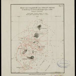
Kaart van een gedeelte van Straat Soenda ter berekening van de hoeveelheid uitgeworpen stoffen

event1883

location_onIndonesia

A map showing the results of the 1883 eruption of the Krakatoa volcano. Black numbers indicate sea depth before the eruption; red numbers are after.

Kaart van het westelijk gedeelte van den Indischen Archipel

event1883

location_onIndonesia, Malaysia, Singapore

The shaded area on this map is where volcanic ash fell from the 1883 eruption of Krakatoa (Sunda Strait between Sumatra and Java). Red figures record the thickness of the ash in millimetres; black figures are distance from the eruption in kilometres.

Kaart van het terrein des oorlogs in Groot-Atjeh

event1883

location_onIndonesia

The Aceh War (1873–1904) between the Sultanate of Aceh and Dutch colonists is highlighted on this map of Groot-Atjeh in 1876. Flag symbols mark the locations of Dutch military posts, and some villages are described as ‘verbrande [burnt]’.

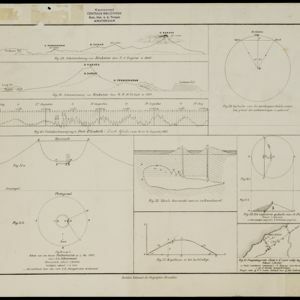
[Grafieken en tekeningen betreffende de uitbarsting van de Krakatau in 1883]

event1883

location_onIndonesia

A series of graphs and drawings about the 1883 eruption of the Krakatoa volcano. Includes elevation views from 1849 and 1880, a globe showing where the eruption was heard, a sketch of the crater of one of the cones, and a cross-section of a volcano.

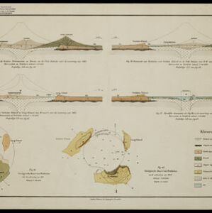
[Doorsneden en geologische kaart van de Krakatau voor en na de ineenstorting van 1883]

event1883

location_onIndonesia

Two geological maps and four sectional drawings showing the Krakatoa volcano before and after its 1883 eruption.

Wereldkaart volgens Mercator's projectie

event1883

location_onBrunei, Cambodia, East Timor, Indonesia, Laos, Malaysia, Myanmar, Papua New Guinea, Philippines, Singapore, Southeast Asia, Thailand, Vietnam

A map charting the effects of the 1883 Krakatoa volcanic eruption: a red circle where the eruption was heard; black lines showing the hourly spread of the resulting waves; and a list of ships on which ash fell, or that encountered pumice (with date).

close