
Search Results


Stromkarte von West Borneo... mit Angabe der Stationen und Routen der Niederländischen Expedition in den Jahren 1893 und 1894
1895
Indonesia
The route of a late 19th century expedition by Dutch geologists, botanists, ethnographers and zoologists is marked on this map of southwest Borneo. Mountain peaks which were surveyed by the geologists are highlighted with a red circle.


Topographische kaart der residentie Soerabaja
1895
Indonesia
The residency of Soerabaja, East Java, featuring crops (coffee, coconut, sugarcane, rice, alang-alang, bamboo) and fishing ponds. Three inset maps: a triangulation map; a map of distances between settlements by types of transport; Bawean Island.
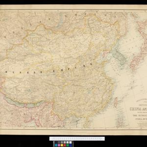
Stanford's Map of the Empires of China & Japan with the adjacent parts of the Russian Empire, India, Burma &c.
1895
Myanmar, Vietnam
The most northern part of Southeast Asia is shown on this map of China and Japan, with Burma (Myanmar) and Tong King (Vietnam) appearing at the bottom of the map. Mountains, rivers and settlements are marked, as well as a railway line in Burma.


The chief passes from Siam into Tavoi / The Siamese Malay States
1895
Myanmar, Thailand, Malaysia
Two maps of Siam (Thailand). The larger map shows routes through mountain passes from Siam to the city of Tavoi (Dawei, on the west coast of Myanmar). The smaller map is marked with trade routes around Lower Siam (Southern Thailand).


