Search

Search Results

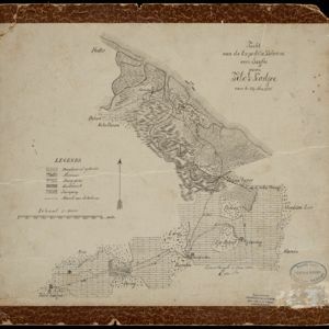
Tocht van de expeditie kolonne over Seglie naar Telok Kadjoe van 6-24 Mei 1878

event1879

location_onIndonesia

Map of a Dutch military expedition from Seglie (Sigli) on the northeast coast of Sumatra to Telok Kadjoe, during the Aceh War between Aceh and Dutch colonists. They land at Sigli and cross marshland, high grass, and rice and sugarcane fields.

Topographische kaart der residentie Kediri

event1879

location_onIndonesia

Four-sheet topographic map of the residency of Kediri (East Java), divided into regencies (pink borders) and districts (yellow borders). Mountains, forests, settlements, routes and crops—sugarcane, alang-alang, rice, coffee, sugar, nutmeg—are shown.

Algemeene kaart van Nederlandsch Indië

event1879

location_onCambodia, Indonesia, Papua New Guinea, East Timor, Southeast Asia, Thailand, Malaysia, Philippines, Laos, Vietnam, Singapore, Brunei, Myanmar

A late 19th century map of the Dutch East Indies on four sheets, detailing maritime routes around the region. There are also inset maps showing railways, rivers, roads, and telegraph systems, as well as individual islands and cities.

close