Search

Search Results

Sketch Map of Mai Cussa or Baxter River, and Wasu Cussa or Chester River, with their tributaries

event1888

location_onPapua New Guinea

Map of an expedition along two rivers on the southern coast of British New Guinea, with notes of terrain (‘Undulating country’), vegetation (‘Coconut Palms’) and wildlife (‘Flying Foxes’). More details have been added by hand (‘Ridge about 10ft.’).

Malay Archipelago, or East India Islands

event1851

location_onBrunei, Cambodia, East Timor, Indonesia, Laos, Malaysia, Myanmar, Papua New Guinea, Philippines, Singapore, Southeast Asia, Thailand, Vietnam

This mid-19th century map of Southeast Asia is illustrated with drawings of indigenous people from New Guinea, a ‘bee bear’ (probably a sun bear), a sailboat in front of Victoria Mount in New Guinea, and a village and palm trees in Sarawak, Borneo.

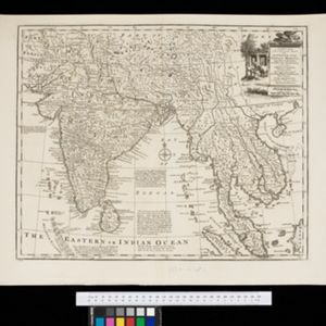
A new and accurate map of the Empire of the Great Mogul, together with India on both sides of the Ganges, and the adjacent countries

eventc.1740

location_onCambodia, Indonesia, Laos, Malaysia, Myanmar, Singapore, Thailand, Vietnam

Notes on this map describe European colonial territories and trade with Asia, though this is concentrated around India, and mostly has not yet reached further east to ‘India extra Gangem [India beyond the Ganges]’ as Southeast Asia is labelled.

Description of East India

event1625

location_onMyanmar

The city of Pegu (Bago, Myanmar), some other settlements, and a river named Martabam Auia are shown in the lower right of this 17th century map of Hindustan (Indian subcontinent). The genealogical seal of the Mughal emperors of India is top right.

Exacta & accurata delineatio cum orarum maritimarum tum etiam locorum terrestrium quae in regionibus China, Cauchinchina, Camboia sive Champa, Syao, Malacca, Aracan & Pegu

event1598

location_onBrunei, Cambodia, East Timor, Indonesia, Laos, Malaysia, Myanmar, Philippines, Singapore, Southeast Asia, Thailand, Vietnam

Unusually, north is located to the left of this map of East Asia, rather than the top. The text notes that shallows and reefs are marked, and that the map is based on the explorations of Portuguese ships. Illustrations include sea monsters and ships.

close