
Search Results

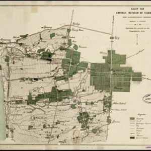
Kaart van Ampenan, Mataram en Tjakranagara met aangrenzend terrein
1895
Indonesia
A map of Mataram in the late 19th century showing it as a kampong (village) surrounded by paddy fields (rectangular parcels of land for growing rice). The map’s whole area is now just part of what is the largest city on the island on Lombok.


Topographische kaart der residentie Soerabaja
1895
Indonesia
The residency of Soerabaja, East Java, featuring crops (coffee, coconut, sugarcane, rice, alang-alang, bamboo) and fishing ponds. Three inset maps: a triangulation map; a map of distances between settlements by types of transport; Bawean Island.


