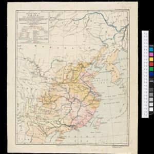
Sketch map of China and adjoining regions: showing the density of population, mineral resources, chief products, principal trade routes, existing and projected railways, and inland navigation
event1898
location_onMyanmar, Thailand, Vietnam
Facsimile of map given to the French Ambassador 29th Aug. 1889 as indicating the Approximate Boundaries of Siam to the North West & North such as they have hitherto been considered
Map of the Burman Empire including also Siam, Cochin-China, Ton-king and Malaya
event1842
location_onVietnam, Malaysia, Myanmar, Cambodia, Thailand, Laos, Indonesia, Singapore, Brunei
Map of the Burman Empire including also Siam, Cochin-China, Ton-king and Malaya
event1842
location_onVietnam, Myanmar, Malaysia, Indonesia, Thailand, Laos, Cambodia, Brunei, Singapore
Map of the Burman Empire including also Siam, Cochin-China, Ton-king and Malaya
eventc.1840-1852
location_onVietnam, Malaysia, Myanmar, Cambodia, Thailand, Laos, Singapore, Brunei
Map of the Burman Empire including also Siam, Cochin-China, Ton-king and Malaya
event1832
location_onVietnam, Myanmar, Malaysia, Indonesia, Thailand, Laos, Cambodia, Brunei, Singapore
The coast of India and China from the point and river of Camboja to Canton: comprehending the coasts of Tsiompa and Cochinchina, with the coast of Tonkin and the coast of Koan-Ton, with the isle of Hai-nan
event1794
location_onCambodia, Vietnam
Carte du Cours de la Riviere de Tunquin: depuis Cacho jusqu'à La Mer
event1755
location_onVietnam
Carte du Cours de la Riviere de Tunquin: depuis Cacho jusqu'à La Mer