Search

Search Results

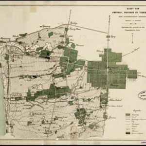
Kaart van Ampenan, Mataram en Tjakranagara met aangrenzend terrein

event1895

location_onIndonesia

A map of Mataram in the late 19th century showing it as a kampong (village) surrounded by paddy fields (rectangular parcels of land for growing rice). The map’s whole area is now just part of what is the largest city on the island on Lombok.

Lombok

event1895

location_onIndonesia

Two maps of Lombok (Lesser Sunda Islands) from the time of the Dutch intervention which led to the colonisation of the island. Both maps focus on roads: the first covers the whole island; the second focuses on the capital city of Mataram.

[Lombok]

event1895

location_onIndonesia

This map of Lombok, in the Lesser Sunda Islands, mainly focuses on roads (marked in red) between the larger settlements. Mountains and rivers are also marked, with shoals, reefs and anchor points around the coast.

La ville de Materan, capitale du roiaume de même nom, avec ses environs: le tout environné de montagnes qui lui serve de murailles

event1729

location_onIndonesia

This map of the city of Mataram, on the Indonesian island of Lombok, shows the city surrounded by detailed illustrations of mountains which, the map’s subtitle notes, ‘serve de murailles’ [serve as its walls].

close

  • Filter from 1729 to 1895

Current results range from 1729 to 1895