
Search Results


Stanford's Map of the Empires of China & Japan with the adjacent parts of the Russian Empire, India, Burma &c.
1896
Myanmar, Vietnam
The most northern part of Southeast Asia is shown on this map of China and Japan, with Burma (Myanmar) and Tong-King (Vietnam) appearing at the bottom of the map. Mountains, rivers and settlements are marked, as well as a railway line in Burma.
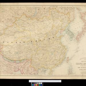
Stanford's Map of the Empires of China & Japan with the adjacent parts of the Russian Empire, India, Burma &c.
1895
Myanmar, Vietnam
The most northern part of Southeast Asia is shown on this map of China and Japan, with Burma (Myanmar) and Tong King (Vietnam) appearing at the bottom of the map. Mountains, rivers and settlements are marked, as well as a railway line in Burma.

Map to illustrate Convention of March 1st 1894 between Great Britain and China: From the Map of Upper Burma
1894
Myanmar
Map of the border region between the Shan States of northeast Burma (Myanmar) and China's Yunnan Province, illustrating the result of the 1894 Sino-British boundary convention. The Burma side is more detailed, with mountains, rivers and settlements.

Trade Routes in the Far East
1894
Brunei, Cambodia, Indonesia, Laos, Malaysia, Myanmar, Philippines, Singapore, Thailand, Vietnam
Map of stream ship trade routes around Southeast Asia. Rivers, railways, submarine telegraph cables, lighthouses (fixed, revolving and flashing), graving docks and coaling stations are marked. An inset map shows a railway route from Britain to Asia.

South eastern frontier: Reconnaissance survey of the route followed by Lieut. Daly's party towards the China frontier
c.1890-1891
Myanmar
A map of the route of a British Army expedition near the border of Upper Burma with China. High points are marked with their heights so they can be used for triangulation. Settlements, rivers, trade routes and footpaths are also shown.

South eastern frontier
c.1890-1906
Myanmar, Thailand
Very detailed large-scale map of the southeast border of Burma (Myanmar) and Siam (Thailand), divided into districts. Spread over multiple sheets, seems incomplete (some sheets appear more than once, probably from different versions of the same map).

India, Burmah and the adjacent parts of Beluchistan, Afghanistan, Turkestan, the Chinese Empire, and Siam
1887
Myanmar, Thailand, Malaysia, Indonesia
British Burma is shown on the right of this two-sheet map of India. The green areas had come under British rule after the first and second Anglo-Burmese wars, with Upper Burma (light brown) being incorporated after the Third Anglo-Burmese War (1885).

Parts of Burma, Siam and the Shan States
1886
Myanmar, Thailand
This map charts the journey of Holt S. Hallett as he searched for a suitable route for a railway to transport British goods from Burma to Thailand and China. He wrote the book ‘A Thousand Miles on an Elephant in the Shan States’ about his expedition.

The external trade routes of India: with tables showing the amount and value of the principal exports and imports of the chief Indian sea ports and frontier states
1886
Myanmar, Thailand
This map of the trade routes of India includes Burma (Myanmar) and part of Siam (Thailand). The Rangoon and Irrawaddy Valley State Railway is marked. There are tables showing the values of imports and exports for each area, listed by produce type.

Map of Burmah, and adjacent countries
1875
Myanmar, Thailand
Small notes on this map of Burmah (Myanmar) describe mines, crops and products produced, names of local tribes etc. e.g.: ‘a passage to Rangoon in the wet season’, ‘Ship of 400 tons built here’, ‘Alompra’s birth place’, ‘Gold dust in the streams’.
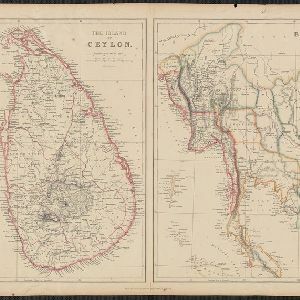
The Island of Ceylon / Burmah, Siam and Anam
1870
Myanmar, Laos, Cambodia, Thailand, Vietnam, Malaysia
This map of mainland Southeast Asia has colour-coded borders: Burmah (Myanmar) in red, Siam (Thailand) in brown, and Anam (Vietnam) in green. The British territory of Penang is also bordered in red. Independent areas are bordered in grey.


