Search

Search Results

Oudheidkundige kaart van Oost-Java tot aan de vorstenlanden

event1889

location_onIndonesia

This map of eastern Java uses red symbols to mark the locations of antiquarian sites, including tjandis (Hindu tombs), walls, terraces, fortifications, temples, wells, statues and cemeteries. Rivers, roads and railways are also shown.

Kaart van den vierkanten paal gouvernements grondgebied te Ngabang

event1888

location_onIndonesia

Map of the town of Ngabang, on the Landak River, Borneo and the surrounding forest and mountains. Around the town are cemeteries, a well, a jail and a Chinese temple. Bamboo, coconut trees, fishing ponds and fields (including alang-alang) are marked.

Kaart van Sintang en omstreken

event1888

location_onIndonesia

The Kapoewas (Kapuas) and Melawi rivers converge on this map of the town of Sintang, Borneo. The town lines the river banks, surrounded by forest, wetlands, fields, bamboo, and coconut trees. Arrows on the rivers mark the direction of their flow.

Kaart van den vierkanten paal (I en II) gouvernements grondgebied te Sintang

event1888

location_onIndonesia

The Kapoewas (Kapuas) and Melawi rivers converge on this map of the town of Sintang, Borneo. The town lines the river banks, and is surrounded by fields, forest and marshland. Arrows on the rivers mark the direction of their flow.

Plan topographique de l'arrondissement de Tan An

event1888

location_onVietnam

Map of the district of Tan An (Tân An in the Mekong Delta, Vietnam) dominated by the two branches of the Vàm Cỏ River. The city of Tan An is in the centre of the more populated southern part of the district.

Plan topographique de l'arrondissement de Tra Vinh

event1888

location_onVietnam

Map of the province of Tra Vinh (Trà Vinh in the Mekong Delta, Vietnam) situated between the mouths of the Sông Cổ Chiên and Bassac rivers. The city of Tra Vinh is towards the north, surrounded by fields, villages, rivers and roads.

Kaart van het Zuidwestelijk gedeelte van het landschap Mampawah, residentie Wester-afdeeling van Borneo

event1887

location_onIndonesia

Map of the crops—coconut, alang-alang, rice, nipa palm, bamboo—grown along the Mempawah River (west coast of Borneo). There are also large areas of swampy forest, Malay mosques, shrines and graveyards, and Chinese villages, temples and graveyards.

Parts of Burma, Siam and the Shan States

event1886

location_onMyanmar, Thailand

This map charts the journey of Holt S. Hallett as he searched for a suitable route for a railway to transport British goods from Burma to Thailand and China. He wrote the book ‘A Thousand Miles on an Elephant in the Shan States’ about his expedition.

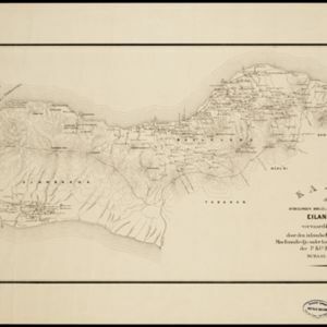
Kaart der afdeelingen Boelèlèng en Djambrana, eiland Bali, vervaardigd in 1885

event1886

location_onIndonesia

Contour lines show the terrain of these two districts at the western end of the island of Bali. Roads connecting the ‘desa’s [villages]’, Hindu temples and rivers are marked. Anchor points around the coast are marked for ships or for local vessels.

Plan topographique de l'arrondissment de Longxuyen

event1886

location_onVietnam

Map of the district of Longxuyen (Long Xuyên in the Mekong Delta, Vietnam). The city of Long Xuyên is on the southern bank of the Bassac River (labelled ‘Fleuve Postérieur’ and ‘Fleuve Antérieur’), surrounded by rivers, wetlands, fields and villages.

Plan topographique de l'arrondissement de Vinh Long

event1885

location_onVietnam

Map of the province of Vinh Long (Vĩnh Long in the Mekong Delta, Vietnam) on the southern bank of the Cổ Chiên River. The city of Vinh Long is on the river, surrounded by rivers, roads, fields and villages.

Itinéraire de Hanoi à That-khe par Lang-son (Frontière Chinoise du Kouang-Si)

event1881

location_onVietnam

A late 19th century map depicting a route from Hanoi to That-Khe via Lang-Son (in northern Vietnam, near the border with China at Kouang-Si (Guangxi)). Two inset maps feature plans of military forts, villages, rivers and fields along the route.

close