Search Results

Kaart van de Residentie Madoera en Onderhoorige Eilanden
1858
Indonesia
Map of the Dutch colonial administrative region of the island of Madoera (Madura), featuring bathymetry (sea depth), and an inset map of the Kangean Islands. (From ‘Algemeene Atlas van Nederlandsche Indie [General Atlas of the Dutch East Indies]’.)

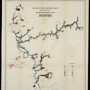
Bijdrage tot eene geologische kaart der residentie Westerafdeeling van Borneo
1858
Indonesia
A geological map of western Borneo made by a mine engineer, showing the types of soil, coal, clay, and rock (limestone, sandstone, granite, basalt), as well as gold, diamonds, tin, copper and iron found along the rivers.

Kaart van de westerhelft der residentie Rembang
1858
Indonesia
Topographic map of the residency of Rembang, Central Java, divided into regencies and districts. Roads and villages are marked, with shoals, reefs and water depth at sea. An inset map of the city of Rembang features markets, warehouses, churches.

Arracan: chart of the entrance to the river
1858
Myanmar
This navigation map of the mouth of the Kaladan River on the west coast of Arracan (modern Myanmar) features drawings of coastal features (elevations), bathymetry (sea depth), shoals and reefs, landmarks, and notes on how to enter the river safely.

Asiatic archipelago
1858
Vietnam, Myanmar, Papua New Guinea, Philippines, Singapore, Southeast Asia, Thailand, Malaysia, Laos, Indonesia, East Timor, Cambodia, Brunei
This late 19th century map of Southeast Asia shows the best maritime routes around the region, according to the time of year. There are also inset maps highlighting the rivers and southern islands of Singapore, and the sea depth around Labuan Island.

Kaart van de Residentie Preanger Regentschappen: No. I
1857
Indonesia
Map of the Dutch colonial administrative region (residency) of Preanger Regentschappen, Java with warehouses, factories, mills, cinchona (‘kina’) plantations. (From ‘Algemeene Atlas van Nederlandsche Indie [General Atlas of the Dutch East Indies]’.)

Kaart van de Residentie Preanger Regentschappen: No. II
1857
Indonesia
Map of the Dutch colonial administrative region (residency) of Preanger Regentschappen, Java with warehouses, factories, mills, cinchona (‘kina’) plantations. (From ‘Algemeene Atlas van Nederlandsche Indie [General Atlas of the Dutch East Indies]’.)
- Filter from 1478 to 1900
- Indonesia934
- Malaysia563
- Thailand524
- Myanmar523
- Singapore489
- Vietnam479
- Cambodia454
- Laos433
- Brunei427
- Philippines416
- East Timor362
- Southeast Asia355
- more Simple Location »
- Java582
- Sumatra576
- Borneo480
- Malay Peninsula425
- Dutch East Indies379
- Sulawesi370
- Celebes302
- Siam285
- Western New Guinea247
- Maluku Islands239
- Sunda Islands194
- Malacca189
- more Detailed Location »
- Port140
- Pier62
- Railway Station49
- [remove]River1,179
- Road391
- Path205
- Railway/Tramway158
- Canal92
- Postal Route87
- Bridge79
- Telegraph/Telephone50


