Search

Search Results

Kaart van de Kleine Soenda eilanden

event1898

location_onIndonesia

The Lesser Sunda Islands are shown spread over these three late 19th century maps. Each island is divided into local administrative districts, with cities, mountains and routes marked. Shoals, lighthouses and anchor points are shown at the coasts.

Kaart van het Eiland Bali

event1897

location_onIndonesia

Bali under Dutch colonial rule is shown here divided into eight regencies (administrative divisions). Contour lines indicate elevation, with the heights of some mountains noted. Shoals, reefs and sandbanks are marked around the coast.

Kaart van het Eiland Bali

event1856

location_onIndonesia

Map of the Dutch colonial region of the island of Bali, featuring bathymetry (sea depth) in the Bali Strait, and an elevation showing heights of mountains. (From ‘Algemeene Atlas van Nederlandsche Indie [General Atlas of the Dutch East Indies]’.)

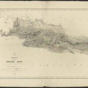
Kaart van het eiland Java

event1845

location_onIndonesia

This map of Java uses hachures: short lines/dashes that give a sense of the shape and steepness of terrain. The coast is marked with shoals and reefs (dotted lines and crosses), bathymetry (sea depth, in figures) and anchor points (anchor symbols).

Nieuwe en zeer naaukeurige kaart van t eyland Java Major of Groot Java: verdeeld in seven byzondere bestekken

event1728

location_onIndonesia

On this beautifully illustrated and coloured map of Java, mountains, trees, fields of crops and settlements are shown pictorially. The coasts are marked with shoals, reefs, bathymetry (sea depth, in figures) and anchor points.

Nieuwe en zeer naaukeurige kaart van t eyland Java Major of Groot Java: verdeeld in seven byzondere bestekken

eventc.1726

location_onIndonesia

On this beautifully illustrated and detailed map of Java, mountains, trees, fields of crops and settlements are shown pictorially. The coasts are marked with shoals, reefs, bathymetry (sea depth, in figures) and anchor points.

close

  • Filter from 1726 to 1898

Current results range from 1726 to 1898