Search

Search Results

Geognostisch-Mijnbouwkundige Kaart van het Eiland Bangka, Distrikt Toboali

event1872

location_onIndonesia

This geological map of the district of Toboali (Bangka Island, east of Sumatra) uses colours to depict types of rocks, soils and minerals. Tin mining areas are also highlighted.

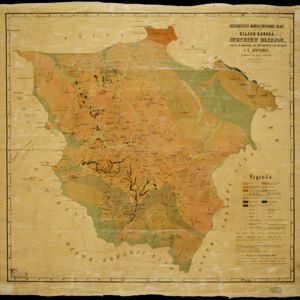
Geognostisch-mijnbouwkundige kaart van het eiland Bangka, distrikt Blinjoe

event1872

location_onIndonesia

A geological map showing the types of rock and minerals found in Blinjoe district on the island of Bangka, off the east coast of Sumatra. Deposits of iron, quartz and tin are marked, and coral is shown at the coast.

Kaart van Sumatra

event1872

location_onIndonesia, Malaysia

A map of the administrative divisions of Sumatra and the Malay Peninsula. The mountains of western Sumatra and the central Malay Peninsula are represented by hachures: short lines/dashes that give a sense of the shape and steepness of terrain.

Kaart van de residentie Pekalongan

event1872

location_onIndonesia

Map of the residency of Pekalongan, Central Java, divided into two regencies (Pekalongan and Batang) and 12 districts. The southern half is dominated by mountains, with more towns in the northern half near the sea. Sugar factories are marked.

Kaart van de onderneming Pengging Bangat

event1872

location_onIndonesia

Map of an estate/plantation, with land/fields coloured to show their use/crop, and marked in red with their size. The map was made with information from village chiefs, whose villages are marked. A small painting depicts an aqueduct over a river.

Kaart van de Hoofdplaats Djokjakarta en Omstreken

event1872

location_onIndonesia

Map of the city of Djokakarta (Yogyakarta, Java), featuring streets and buildings, as well as a military fort, public square and railway station. The surrounding area has rice (paddy) fields and villages.

close