Search

Search Results

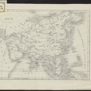
Azie

eventc.1900

location_onBrunei, Cambodia, East Timor, Indonesia, Laos, Malaysia, Myanmar, Papua New Guinea, Philippines, Singapore, Southeast Asia, Thailand, Vietnam

Dutch-language map of Asia, with mainland Southeast Asia labelled ‘Achter Indie [Beyond India]’.

Eiland Sebangka

eventc.1900-1909

location_onIndonesia

Map of the island of Sebangka (Lingga Regency, off the east coast of Sumatra), spread over four sheets. It features settlements, crops and plantations, rivers, mountains (with their heights) and wetlands. Only three of four sheets are available.

Eiland Temiang

eventc.1900-1909

location_onIndonesia

Map of the island of Temiang (Lingga Regency, off the east coast of Sumatra), featuring crops (coconut, alang-alang), mangroves, mountains (with their heights) and villages. Spread over five sheets, may not be complete or all from same original map.

[Various Indonesian islands]

eventc.1900

location_onMalaysia, Brunei, Indonesia, Singapore

Seven locations in the Dutch East Indies on one sheet: the islands of Borneo, Sumatra, Celebes (Sulawesi), Ambon and Banda, the city of Padang and its region on the west coast of Sumatra, and the tip of the Minahasa Peninsula (northern Celebes).

Azie

eventc.1900

location_onBrunei, Cambodia, East Timor, Indonesia, Laos, Malaysia, Myanmar, Papua New Guinea, Philippines, Singapore, Southeast Asia, Thailand, Vietnam

Dutch-language map of Asia, with mainland Southeast Asia labelled ‘Achter Indie [Beyond India]’.

Zuidelijk gedeelte van de Chineesche zee: Blad I

event1899

location_onMalaysia, Singapore, Indonesia

Navigation map of the southern part of the South China Sea, including the straits of Malacca and Singapore, and the Riau Archipelago. Bathymetry (sea depth), lighthouses, shoals and other obstructions are marked, with hills to use as landmarks.

Historische, chronologische overzichtskaart van den Atjeh oorlog

event1898

location_onIndonesia

The Aceh War (1873–1904) between the Sultanate of Aceh and Dutch colonists is highlighted on this map, with areas coloured to show when the Dutch conquered them. Settlements are marked with flags indicating their status; military roads are in red.

Zuidelijk gedeelte van Straat Malaka

event1899

location_onIndonesia

Navigation map of the southern part of the Strait of Malacca. Bathymetry (sea depth), lighthouses (in red and yellow), shoals and other obstructions (clay, coral, mud, rocks, shells, stones, sand) are marked, with hills to use as landmarks.

Kaart van Groot Atjeh, 1874-1895

event1899

location_onIndonesia

This map of Groot Atjeh (Aceh, northern Sumatra) focuses on Dutch military posts in and around the city of Kota Radja (Banda Aceh) during the Aceh War. It shows new permanent and temporary posts being added over the period 1874 to 1895.

Kaart van de Vallei van Pidië, de Moekim VII en de Vallei van Tangsé

event1899

location_onIndonesia

Large-scale topographic map of the northeast coast of Sumatra around the city of Sigli, Aceh, spread over 16 sheets plus a cover sheet of the whole area. The map focuses on two river valleys, mountains, marshland, villages and rice paddies.

Sumatra

eventc.1899-1902

location_onIndonesia

Eight sheets from a large-scale detailed topographic map of Sumatra (many other sheets are missing). Includes crops (rice, coconut, coffee, banana, sugar, gambier, cinnamon, bamboo, alang-alang, arenga palm), routes (railways, roads), settlements.

Kaart van het gebied bezet in Groot-Atjèh

event1898

location_onIndonesia

A six-sheet map of Groot-Atjèh (Aceh, northern Sumatra) focusing on areas occupied during the Aceh War (1873–1904) between the Sultanate of Aceh and Dutch colonists. It shows military positions and fortifications, buildings, routes and crops.

close