Search

Search Results

Westkust Sumatra van Roesa tot Melaboe

event1894

location_onIndonesia

Navigation map of the northwest coast of Sumatra. Bathymetry (sea depth), anchor points, shoals and other obstructions (clay, coral, mud, stones, sand) are marked, with hills and settlements to use as landmarks.

Koninginne baai met Emma haven

event1894

location_onIndonesia

Map of Koninginne Baai (Bayur Bay, west coast of Sumatra) used to navigate Emma Haven (now Port of Teluk Bayur). It features bathymetry (sea depth), reefs and shoals, as well as lighthouses, buoys and two elevations (side views) of coastal mountains.

Kaart van Groot Atjeh

event1894

location_onIndonesia

This map of Groot Atjeh (Aceh, northern Sumatra) focuses on Dutch military posts in and around the city of Kota Radja (Banda Aceh) during the Aceh War. It shows new permanent and temporary posts being added over the period 1884 to 1893.

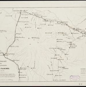
Overzichtskaart van den ontworpen spoorweg Fort de Kock-Pajakombo

event1894

location_onIndonesia

A map of railway lines between Fort de Kock (Bukittinggi) and Pajakombo (Payakumbuh) in western Sumatra. The map includes existing line, planned line and rack railway line (a line with a rack and pinion system so it can operate on steep slopes).

Oostkust Sumatra. Schetskaart der Siak Rivier van het Eiland Tengah tot Siak

event1894

location_onIndonesia

This late 19th century large-scale (1:30,000) map show just a section of the Siak River, in the Riau province of Sumatra. Bathymetry (water depth) is shown in figures to aid navigation, with various landmarks noted along the river’s banks.

close